Hurricane Felix,3 September 2007
Bildnummer 11738092
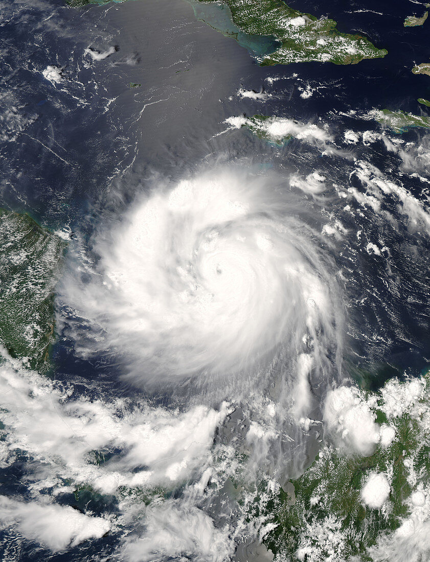
| Hurricane Felix,satellite image. North is at top. Image obtained at 18:30 GMT on 3 September 2007 as the hurricane approached Central America (left) from the Caribbean Sea,moving east to west. After the hurricane passed over the islands Bonaire and Curacao on 2 September,it increased to a category 5 hurricane with wind speeds of up to 270 kilometres per hour. It was still at its most powerful when it hit the Nicaragua-Honduras border and the eye was seen near Punta Gorda,Nicaragua,at 12:00 GMT on 4 September. Hurricane Felix followed less than a month after Hurricane Dean,which severely damaged Jamaica on 19 August 2007. Image from the MODIS instrument on NASA's Aqua satellite | |
| Lizenzart: | Lizenzpflichtig |
| Credit: | Science Photo Library / NASA |
| Bildgröße: | 5200 px × 6800 px |
| Modell-Rechte: | nicht erforderlich |
| Eigentums-Rechte: | nicht erforderlich |
| Restrictions: | - |
Preise für dieses Bild ab 15 €
Universitäten & Organisationen
(Informationsmaterial Digital, Informationsmaterial Print, Lehrmaterial Digital etc.)
ab 15 €
Redaktionell
(Bücher, Bücher: Sach- und Fachliteratur, Digitale Medien (redaktionell) etc.)
ab 30 €
Werbung
(Anzeigen, Aussenwerbung, Digitale Medien, Fernsehwerbung, Karten, Werbemittel, Zeitschriften etc.)
ab 55 €
Handelsprodukte
(bedruckte Textilie, Kalender, Postkarte, Grußkarte, Verpackung etc.)
ab 75 €
Pauschalpreise
Rechtepakete für die unbeschränkte Bildnutzung in Print oder Online
ab 495 €
Keywords
- 21. Jahrhundert,
- aqua,
- Atlantisch,
- Auge,
- Erdbeobachtung,
- extrem,
- gefährlich,
- Honduras,
- Hurrikan,
- Karibisches Meer,
- Kategorie 5,
- Klima,
- Land,
- Meer,
- Meteorologie,
- meteorologisch,
- Mittelamerika,
- modis,
- NASA,
- Ozean,
- rotierend,
- Satellit,
- Satellitenbild,
- Spektroradiometer,
- Tropisch,
- Weltall,
- Wetter,
- Wolke,
- Wolken,
- Zentralamerika