Russian heatwave,summer 2010
Bildnummer 11592400
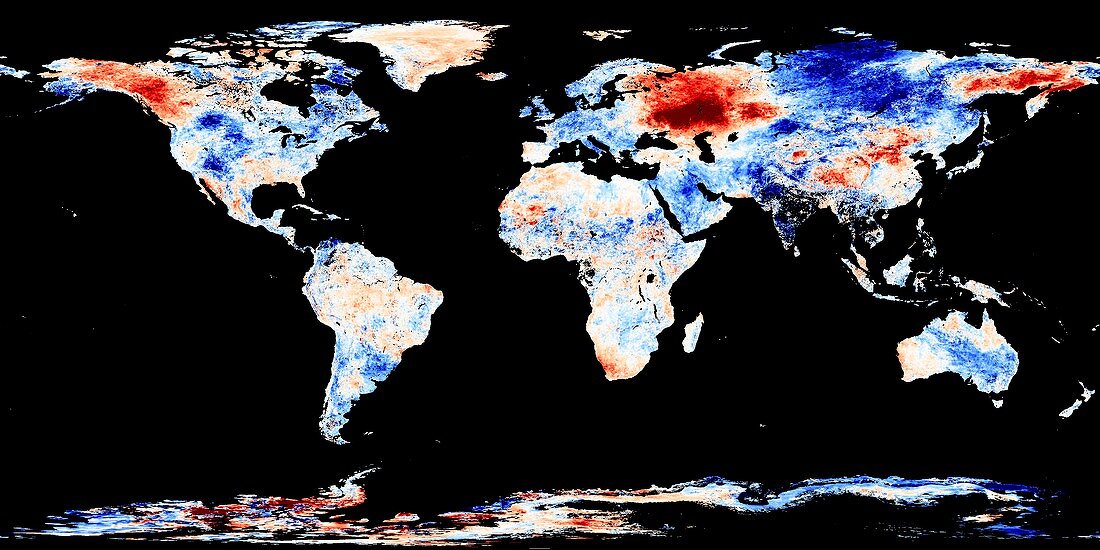
| Russian heatwave,July 2010. This world satellite map shows global land surface temperature anomalies in the period from 28 July to 4 August 2010,as compared to the same period in the years 2000 to 2008. Red indicates hotter temperatures and blue indicates cooler temperatures. The extremes (dark blue and dark red) were twelve degrees Celsius cooler and hotter. The most prominent feature here is the dark orange area in western Russia. Extensive wildfires broke out here during the Northern Hemisphere heatwave. Data obtained by the MODIS sensor on NASA's Terra satellite | |
| Lizenzart: | Lizenzpflichtig |
| Credit: | Science Photo Library / NASA |
| Bildgröße: | 8268 px × 4134 px |
| Modell-Rechte: | nicht erforderlich |
| Eigentums-Rechte: | nicht erforderlich |
| Restrictions: | - |
Preise für dieses Bild ab 15 €
Universitäten & Organisationen
(Informationsmaterial Digital, Informationsmaterial Print, Lehrmaterial Digital etc.)
ab 15 €
Redaktionell
(Bücher, Bücher: Sach- und Fachliteratur, Digitale Medien (redaktionell) etc.)
ab 30 €
Werbung
(Anzeigen, Aussenwerbung, Digitale Medien, Fernsehwerbung, Karten, Werbemittel, Zeitschriften etc.)
ab 55 €
Handelsprodukte
(bedruckte Textilie, Kalender, Postkarte, Grußkarte, Verpackung etc.)
ab 75 €
Pauschalpreise
Rechtepakete für die unbeschränkte Bildnutzung in Print oder Online
ab 495 €
Keywords
- 2010,
- 21. Jahrhundert,
- August,
- Erde,
- extrem,
- Feuer,
- Gefroren,
- geografisch,
- Geographie,
- Globale Erwärmung,
- heiß,
- Juli,
- Kalt,
- Karte,
- Klimatologie,
- klimatologisch,
- Klimawandel,
- Kühler,
- Meteorologie,
- meteorologisch,
- Modell-,
- modis,
- NASA,
- nördliche Hemisphäre,
- Planet,
- planetarisch,
- Russisch,
- Russland,
- Satellit,
- Satellitenbild,
- Sommer,
- südlichen Hemisphäre,
- Terra,
- Warm,
- Weltall,
- weltweit,
- Wetter,
- Winter