Antarctic sea ice maximum September 2023, satellite image
Bildnummer 14077523
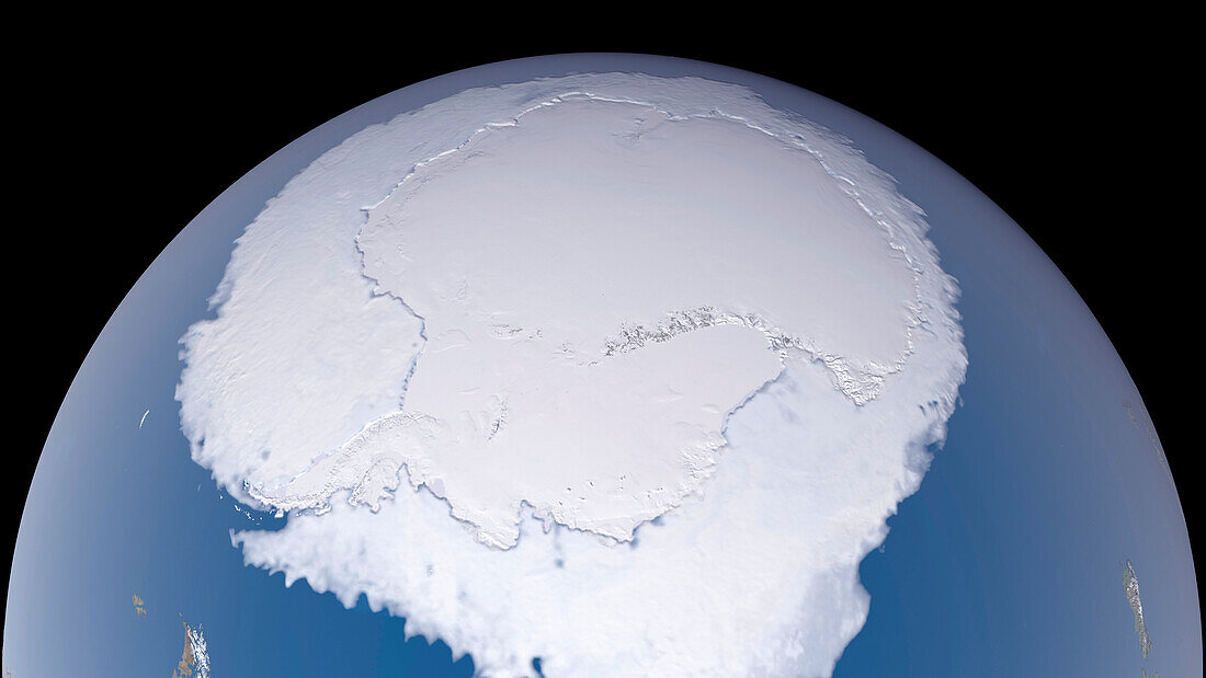
| Satellite image showing the Antarctic sea ice annual maximum on 10 September 2023. The sea ice has grown during the southern hemisphere winter and reached its maximum extent. On this day the sea ice cover peaked at 16.96 million square kilometres, making it the lowest yearly maximum extent on record. Scientists track the seasonal and annual fluctuations because sea ice plays a large role in Earth’s polar ecosystems and global climate. Data collected with the Advanced Microwave Scanning Radiometer 2 (AMSR2) onboard the Japan Aerospace Exploration Agency's (JAXA's) Global Change Observation Mission 1st-Water 'SHIZUKU'(GCOM-W1) satellite. | |
| Lizenzart: | Lizenzpflichtig |
| Credit: | Science Photo Library / Scientific Visualization Studio / NASA / JAXA |
| Bildgröße: | 3840 px × 2160 px |
| Modell-Rechte: | nicht erforderlich |
| Eigentums-Rechte: | nicht erforderlich |
| Restrictions: | - |
Preise für dieses Bild ab 15 €
Universitäten & Organisationen
(Informationsmaterial Digital, Informationsmaterial Print, Lehrmaterial Digital etc.)
ab 15 €
Redaktionell
(Bücher, Bücher: Sach- und Fachliteratur, Digitale Medien (redaktionell) etc.)
ab 30 €
Werbung
(Anzeigen, Aussenwerbung, Digitale Medien, Fernsehwerbung, Karten, Werbemittel, Zeitschriften etc.)
ab 55 €
Handelsprodukte
(bedruckte Textilie, Kalender, Postkarte, Grußkarte, Verpackung etc.)
ab 75 €
Pauschalpreise
Rechtepakete für die unbeschränkte Bildnutzung in Print oder Online
ab 495 €
Keywords
- 1,
- 2000er Jahre,
- 21. Jahrhundert,
- alljährlich,
- Antarktis,
- Eis,
- Erdbeobachtung,
- Erde,
- Erdkunde,
- Gefroren,
- geografisch,
- Geographie,
- Globale Erwärmung,
- Globus,
- jaxa,
- Klima,
- Klimatologie,
- klimatologisch,
- Klimawandel,
- Kontinent,
- Meer,
- Meereis,
- Meerwasser,
- NASA,
- Niemand,
- Ökologie,
- Ökologisch,
- Ökosystem,
- Ozean,
- polar,
- Region,
- saisonal,
- Satellit,
- Satellitenbild,
- schwarzer Hintergrund,
- Südlicher Ozean,
- südlicher Polarkreis,
- Umwelt,
- Welt,
- Weltall