Columbia Glacier retreat from 1986 to 2014, satellite images
Bildnummer 12949153
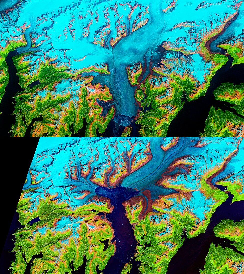
| Columbia Glacier retreat from 1986 to 2014, satellite images. The Columbia Glacier in Alaska, USA, descends from the Chugach Mountains into Prince William Sound. In 1986 (top) the glacier (light blue) extended outwards to Heather Island. The image at bottom is from 2014, showing the extent of the glacier's retreat over the following 28 years. It is thought that the Main Branch of the glacier (upper right) is unstable and further melting may take place. The retreat of glaciers worldwide has been linked to climate change. These images were obtained with the Thematic Mapper (TM) sensor on the Landsat 5 satellite (1986) and the Operational Land Imager (OLI) on the Landsat 8 satellite (2014). | |
| Lizenzart: | Lizenzpflichtig |
| Credit: | Science Photo Library / NASA / US Geological Survey Earth Observatory |
| Bildgröße: | 3947 px × 4440 px |
| Modell-Rechte: | nicht erforderlich |
| Eigentums-Rechte: | nicht erforderlich |
| Restrictions: | - |
Preise für dieses Bild ab 15 €
Universitäten & Organisationen
(Informationsmaterial Digital, Informationsmaterial Print, Lehrmaterial Digital etc.)
ab 15 €
Redaktionell
(Bücher, Bücher: Sach- und Fachliteratur, Digitale Medien (redaktionell) etc.)
ab 30 €
Werbung
(Anzeigen, Aussenwerbung, Digitale Medien, Fernsehwerbung, Karten, Werbemittel, Zeitschriften etc.)
ab 55 €
Handelsprodukte
(bedruckte Textilie, Kalender, Postkarte, Grußkarte, Verpackung etc.)
ab 75 €
Pauschalpreise
Rechtepakete für die unbeschränkte Bildnutzung in Print oder Online
ab 495 €
Keywords
- 1900er Jahre,
- 1980er Jahre,
- 20. Jahrhundert,
- 2014,
- 21. Jahrhundert,
- Alaska,
- Amerikanisch,
- Duo,
- Erdbeobachtung,
- Geschichte,
- Geschmolzen,
- Glaziologie,
- Gletscher,
- Globale Erwärmung,
- historisch,
- Klimatologie,
- klimatologisch,
- Klimawandel,
- Landsat 8,
- Niemand,
- Nordamerika,
- nordamerikanisch,
- oli,
- Paar,
- Reihenfolge,
- Rückzug,
- Satellit,
- Satellitenbild,
- Schmelzen,
- Serie,
- Tm,
- uns,
- USA,
- Vereinigte Staaten,
- vorher,
- Weltall,
- Zwei