New Netherland, 17th century
Bildnummer 12376949
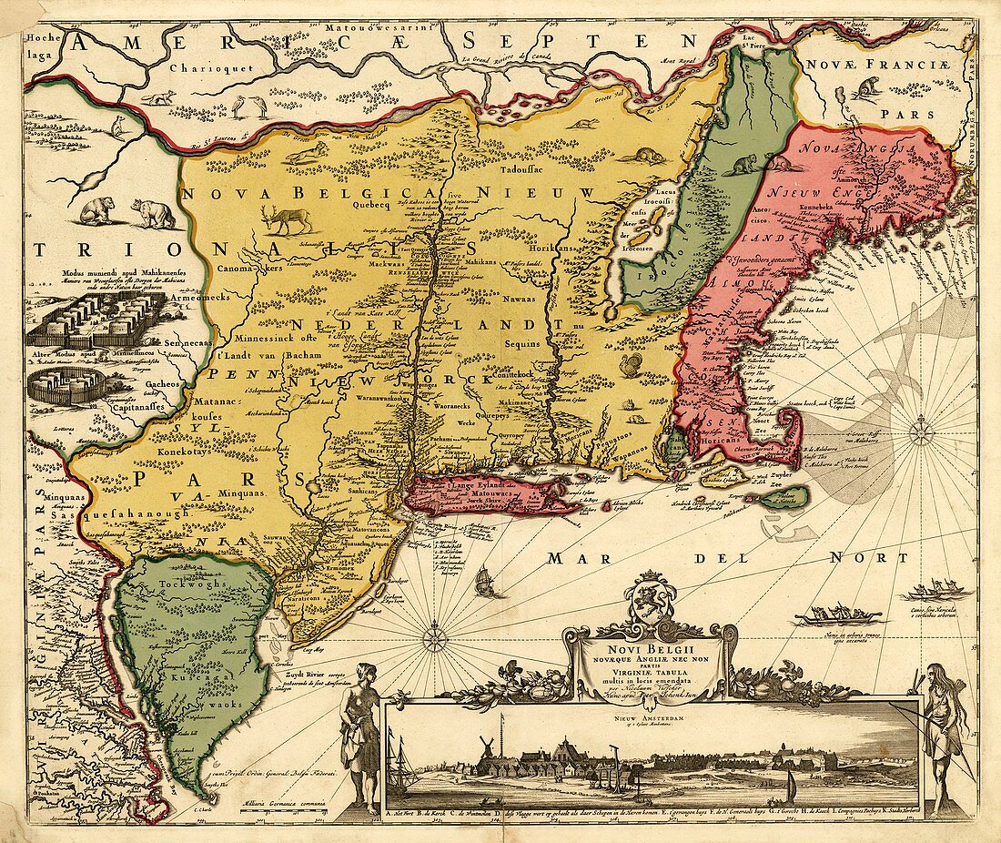
| New Netherland. 17th-century map of the Dutch colony of New Netherland (yellow), which existed in north-eastern North America from 1614 to 1667, and again from 1673 to 1674. The title is in Latin, referring to New Belgium (another name for New Netherland), New England and Virginia. The region later became the colonies and then states of New York, New Jersey, Delaware, and Connecticut. The inset (lower right) shows an early New York City (re-named New York in 1664): 'Nieuw Amsterdam op t eylant Manhattans' (New Amsterdam on the island of Manhatttan). New Amsterdam is at left of Long Island (red, centre). Published in Amsterdam in 1685, this map by Nicolaes Visscher (1649-1702) is thought to date from the early 1650s. | |
| Lizenzart: | Lizenzpflichtig |
| Credit: | Science Photo Library / LIBRARY OF CONGRESS, Geography and Map Division |
| Bildgröße: | 5217 px × 4391 px |
| Modell-Rechte: | nicht erforderlich |
| Eigentums-Rechte: | nicht erforderlich |
| Restrictions: | - |
Preise für dieses Bild ab 15 €
Universitäten & Organisationen
(Informationsmaterial Digital, Informationsmaterial Print, Lehrmaterial Digital etc.)
ab 15 €
Redaktionell
(Bücher, Bücher: Sach- und Fachliteratur, Digitale Medien (redaktionell) etc.)
ab 30 €
Werbung
(Anzeigen, Aussenwerbung, Digitale Medien, Fernsehwerbung, Karten, Werbemittel, Zeitschriften etc.)
ab 55 €
Handelsprodukte
(bedruckte Textilie, Kalender, Postkarte, Grußkarte, Verpackung etc.)
ab 75 €
Pauschalpreise
Rechtepakete für die unbeschränkte Bildnutzung in Print oder Online
ab 495 €
Keywords
- 1600er Jahre,
- 17. Jahrhundert,
- britisch,
- Cape Cod,
- Connecticut,
- Diagramm,
- Englisch,
- europäisch,
- Flämisch,
- Flüsse,
- geografisch,
- Geographie,
- Geschichte,
- historisch,
- Illustration,
- Karte,
- Kartographie,
- Kolonie,
- Kolonien,
- Kunstwerk,
- Küste,
- Küsten-,
- Küstenlinie,
- Long Island,
- Manhattan,
- New Jersey,
- New York,
- New York City,
- Niederländisch,
- Niemand,
- Nordamerika,
- nordamerikanisch,
- NYC,
- USA,
- Vereinigte Staaten,
- Virginia