Waldseemuller map of Lorraine, 16th century
Bildnummer 12376939
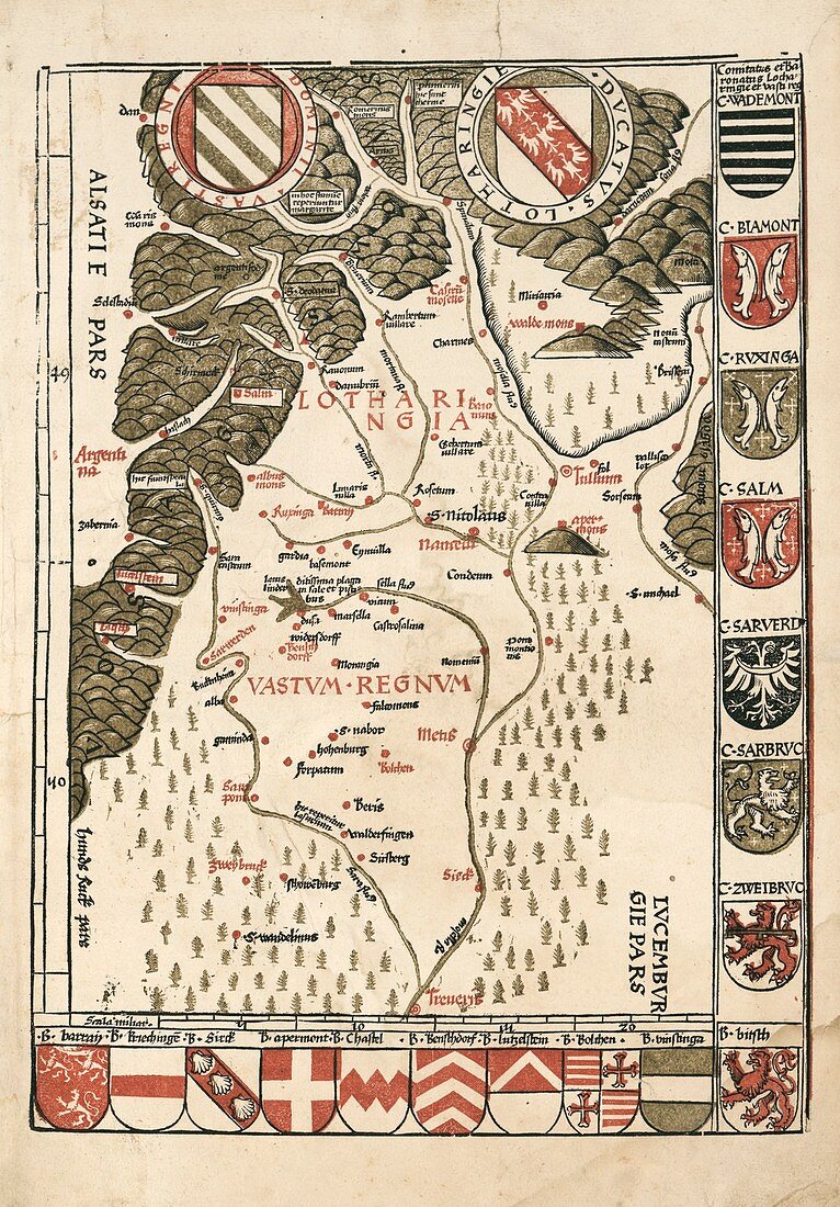
| Waldseemuller map of Lorraine, 16th century. Produced by German cartographer Martin Waldseemuller for his patron Rene II, Duke of Lorraine, this map (first state published in 1513) is considered to be the earliest printed regional map based on systematic surveys. Orientated with North at bottom, the map proclaimed the glory and ambitions of the Duchy of Lorraine ('Lotharingia') and the adjacent Westrich Plateau region ('Vastum Regnum'). These are today parts of France and Germany. The area is drained by the Moselle and Saar rivers, descending from the Vosges Mountains (across top). At top left is Alsace, with Luxembourg at bottom right. Cities include Nancy (centre). The map is adorned with 19 coasts of arms. At top are the arms of the Domain of Westrich and the Duchy of Lorraine. Martin Waldseemueller lived and worked at 'S. deodatus' (Saint-Die-des-Vosges) at upper left. | |
| Lizenzart: | Lizenzpflichtig |
| Credit: | Science Photo Library / LIBRARY OF CONGRESS, Geography and Map Division |
| Bildgröße: | 3511 px × 5041 px |
| Modell-Rechte: | nicht erforderlich |
| Eigentums-Rechte: | nicht erforderlich |
| Restrictions: | - |
Preise für dieses Bild ab 15 €
Universitäten & Organisationen
(Informationsmaterial Digital, Informationsmaterial Print, Lehrmaterial Digital etc.)
ab 15 €
Redaktionell
(Bücher, Bücher: Sach- und Fachliteratur, Digitale Medien (redaktionell) etc.)
ab 30 €
Werbung
(Anzeigen, Aussenwerbung, Digitale Medien, Fernsehwerbung, Karten, Werbemittel, Zeitschriften etc.)
ab 55 €
Handelsprodukte
(bedruckte Textilie, Kalender, Postkarte, Grußkarte, Verpackung etc.)
ab 75 €
Pauschalpreise
Rechtepakete für die unbeschränkte Bildnutzung in Print oder Online
ab 495 €