Larsen C Ice Shelf rift, Antarctica, November 2016
Bildnummer 12325298
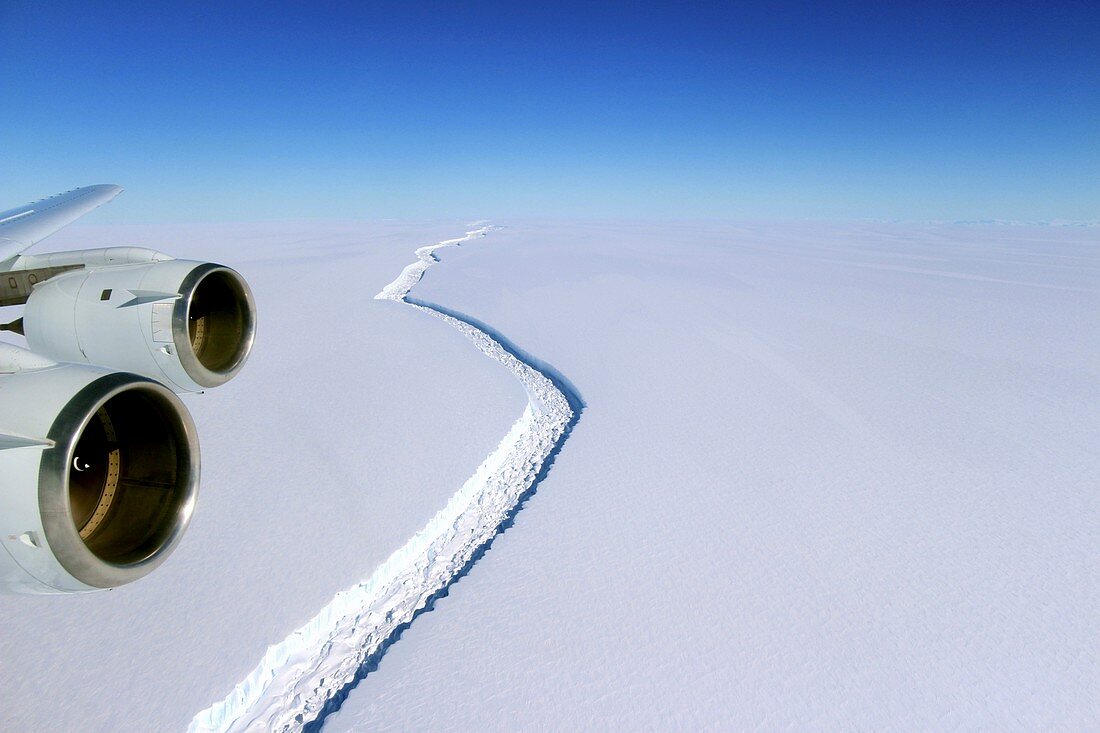
| Larsen C Ice Shelf rift, November 2016, aerial photograph. Wide view of a rift in the Larsen C Ice Shelf, seen from NASA's DC-8 research aircraft as part of an Operation IceBridge flight. The rift in Larsen C measures about 100 metres wide and is about half a kilometre deep, passing completely through to the bottom of the ice shelf. The rift is long and growing longer, but does not yet reach across the entire shelf. At that point, Larsen C will shed a very large iceberg, about 6000 square kilometres in area. The Larsen Ice Shelf extends along the east coast of the Antarctic Peninsula, in the Weddell Sea. Operation IceBridge is a NASA project that monitors polar ice cover using aircraft instead of satellites. It was introduced in 2009 as a replacement for the malfunctioning ICESat satellite. Photographed on 10 November 2016. | |
| Lizenzart: | Lizenzpflichtig |
| Credit: | Science Photo Library / John Sonntag, NASA |
| Bildgröße: | 5131 px × 3420 px |
| Modell-Rechte: | nicht erforderlich |
| Eigentums-Rechte: | nicht erforderlich |
| Restrictions: | - |
Preise für dieses Bild ab 15 €
Universitäten & Organisationen
(Informationsmaterial Digital, Informationsmaterial Print, Lehrmaterial Digital etc.)
ab 15 €
Redaktionell
(Bücher, Bücher: Sach- und Fachliteratur, Digitale Medien (redaktionell) etc.)
ab 30 €
Werbung
(Anzeigen, Aussenwerbung, Digitale Medien, Fernsehwerbung, Karten, Werbemittel, Zeitschriften etc.)
ab 55 €
Handelsprodukte
(bedruckte Textilie, Kalender, Postkarte, Grußkarte, Verpackung etc.)
ab 75 €
Pauschalpreise
Rechtepakete für die unbeschränkte Bildnutzung in Print oder Online
ab 495 €
Keywords
- 2016,
- 21. Jahrhundert,
- Antarktis,
- Antarktische Halbinsel,
- eisig,
- eislandschaft,
- Fliegend,
- Flugzeug,
- Gefroren,
- Geowissenschaften,
- Glaziologie,
- Globale Erwärmung,
- Himmel,
- Horizont,
- Kalt,
- Klimatologie,
- klimatologisch,
- Klimawandel,
- Luftaufnahme,
- Luftaufnahmen,
- Mission,
- Motor,
- NASA,
- Niemand,
- polar,
- Umweltwissenschaften,
- Vogelperspektive