Global map of sea surface height,2016
Bildnummer 12098797
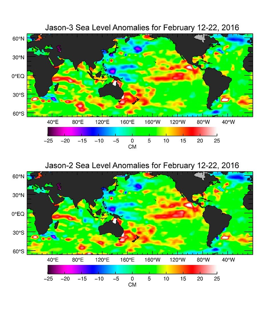
| Global map of sea surface height. Comparison between the sea surface anomaly height maps produced by the Jason-2 (bottom) and Jason-3 (top) satellites from 12-22 February 2016. Green is normal,red/yellow is increased height,and blue/purple is decreased height. The Jason-3 satellite (2016) is a joint mission between NASA,NOAA,CNES and EUMETSAT. The successor to the Jason-2 satellite (launched in 2008),it is carrying out the Ocean Surface Topography Mission (OSTM). This allows global monitoring of tides,ocean currents and oscillations,ocean circulation,and climate change-induced rises in sea levels. The red area in the eastern equatorial Pacific (right) is due to El Nino | |
| Lizenzart: | Lizenzpflichtig |
| Credit: | Science Photo Library / Ocean Surface Topography Science Team / JPL-Caltech / NASA |
| Bildgröße: | 3907 px × 4559 px |
| Modell-Rechte: | nicht erforderlich |
| Eigentums-Rechte: | nicht erforderlich |
| Restrictions: | - |
Preise für dieses Bild ab 15 €
Universitäten & Organisationen
(Informationsmaterial Digital, Informationsmaterial Print, Lehrmaterial Digital etc.)
ab 15 €
Redaktionell
(Bücher, Bücher: Sach- und Fachliteratur, Digitale Medien (redaktionell) etc.)
ab 30 €
Werbung
(Anzeigen, Aussenwerbung, Digitale Medien, Fernsehwerbung, Karten, Werbemittel, Zeitschriften etc.)
ab 55 €
Handelsprodukte
(bedruckte Textilie, Kalender, Postkarte, Grußkarte, Verpackung etc.)
ab 75 €
Pauschalpreise
Rechtepakete für die unbeschränkte Bildnutzung in Print oder Online
ab 495 €
Keywords
- 2016,
- 21. Jahrhundert,
- beschriftet,
- cnes,
- El Nino,
- Erdbeobachtung,
- Erde,
- Etikette,
- EUMETSAT,
- farbcodiert,
- Februar,
- Forschung,
- Geowissenschaften,
- Globale Erwärmung,
- Grafik,
- jason-2,
- jason-3,
- Karte,
- Klimatologie,
- klimatologisch,
- Klimawandel,
- Maßstab,
- Meereskunde,
- NASA,
- Niemand,
- NOAA,
- OSTM,
- Satellit,
- Satellitenbild,
- Schlüssel,
- weißer Hintergrund,
- Welt,
- Weltall,
- weltweit