Kircher's map of Asia,1678
Bildnummer 11904860
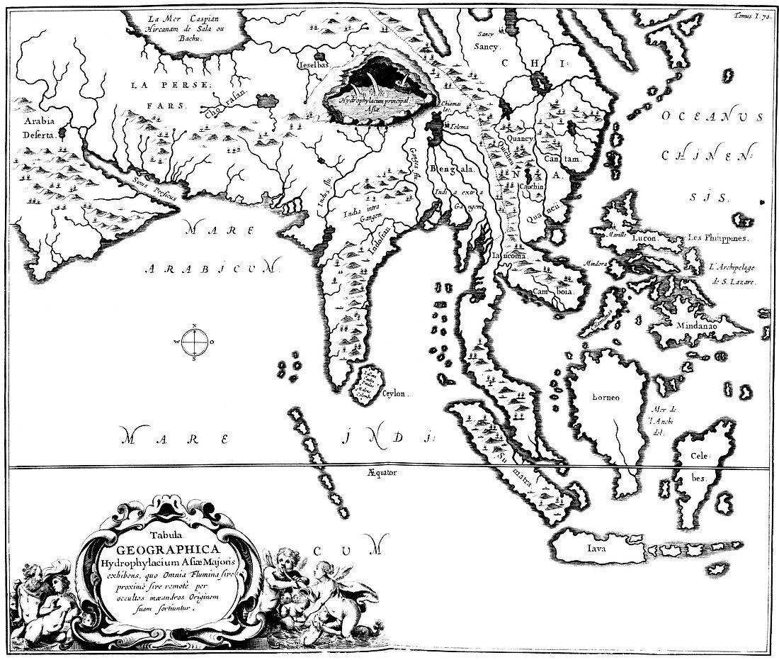
| Kircher's map of Asia. Illustrated map of Asia,from the work Mundus Subterraneus (1678) by the German Jesuit scholar Athanasius Kircher (circa 1601-1680). The map is labelled in Latin,with a title at lower left. The title states that the map shows Asia Major (as opposed to Asia Minor),and that it shows the origin of the water systems of the area. A large underground sea is shown in the region of the Himalayas,providing water for the rivers. Kircher's theory was that underground water,heated by the Earth's internal fires,caused the tides and the eruption of volcanoes | |
| Lizenzart: | Lizenzpflichtig |
| Credit: | Science Photo Library / Royal Astronomical Society |
| Bildgröße: | 4608 px × 3898 px |
| Modell-Rechte: | nicht erforderlich |
| Eigentums-Rechte: | nicht erforderlich |
| Restrictions: | - |
Preise für dieses Bild ab 15 €
Universitäten & Organisationen
(Informationsmaterial Digital, Informationsmaterial Print, Lehrmaterial Digital etc.)
ab 15 €
Redaktionell
(Bücher, Bücher: Sach- und Fachliteratur, Digitale Medien (redaktionell) etc.)
ab 30 €
Werbung
(Anzeigen, Aussenwerbung, Digitale Medien, Fernsehwerbung, Karten, Werbemittel, Zeitschriften etc.)
ab 55 €
Handelsprodukte
(bedruckte Textilie, Kalender, Postkarte, Grußkarte, Verpackung etc.)
ab 75 €
Pauschalpreise
Rechtepakete für die unbeschränkte Bildnutzung in Print oder Online
ab 495 €
Keywords
- 17. Jahrhundert,
- Äquator,
- Arabien,
- Arabisch,
- Asiatisch,
- Asien,
- Athanasius Kircher,
- Bengalen,
- Ceylon,
- China,
- Deutsche,
- Einfarbig,
- europäisch,
- Feuer,
- Fluss,
- Flüsse,
- geografisch,
- Geographie,
- Geologie,
- geologisch,
- geophysikalisch,
- geothermal,
- Geschichte,
- Geschichte der Wissenschaft,
- historisch,
- Hydrologie,
- Illustration,
- Indien,
- Indisch,
- Indonesien,
- Indonesisch,
- Insel,
- Inseln,
- Java,
- Kambodscha,
- Karte,
- Kartographie,
- Kaspisches Meer,
- Kirchers,
- Kontinent,
- Kunstwerk,
- Land,
- Länder,
- Latein,
- Malaiischer Archipel,
- Malaysisch,
- Meer,
- Mindanao,
- Mundus subterraneus,
- Ozean,
- Ozeane,
- Persien,
- Persisch,
- Philippinen,
- Schreiben,
- Schwarz und weiß,
- Sri Lanka,
- Sumatra,
- Text,
- Theorie,
- Tropen,
- Tropisch,
- Untergrund