Rivers on Mars
Bildnummer 11882311
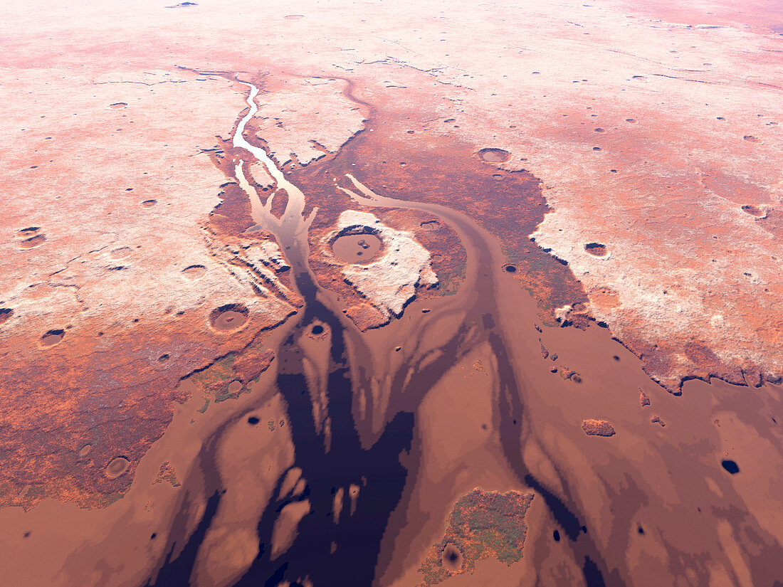
| Rivers on Mars. Computer artwork looking west over the mouth of a river thought to have created the Kasei Valles (Kasei Valley,down left) on Mars 3.5 billion years ago. Meltwater flowed from top,past the Sharanov Crater (centre),entering the sea in the Chryse Planitia (Chryse Plain,not seen,off bottom). Ice (white) is on the heights of Lunae Planum (left) and Tempa Terra (right). The image is hundreds of kilometres across. The water was ultimately lost due to the thin Martian atmosphere and weak gravity. Mars is now a desert world. The topography was drawn with Terragen software,using data from the laser altimeter on the Mars Global Surveyor probe | |
| Lizenzart: | Lizenzpflichtig |
| Credit: | Science Photo Library / Veenenbos, Kees |
| Bildgröße: | 2400 px × 1800 px |
| Modell-Rechte: | nicht erforderlich |
| Eigentums-Rechte: | nicht erforderlich |
| Restrictions: | - |
Preise für dieses Bild ab 15 €
Universitäten & Organisationen
(Informationsmaterial Digital, Informationsmaterial Print, Lehrmaterial Digital etc.)
ab 15 €
Redaktionell
(Bücher, Bücher: Sach- und Fachliteratur, Digitale Medien (redaktionell) etc.)
ab 30 €
Werbung
(Anzeigen, Aussenwerbung, Digitale Medien, Fernsehwerbung, Karten, Werbemittel, Zeitschriften etc.)
ab 55 €
Handelsprodukte
(bedruckte Textilie, Kalender, Postkarte, Grußkarte, Verpackung etc.)
ab 75 €
Pauschalpreise
Rechtepakete für die unbeschränkte Bildnutzung in Print oder Online
ab 495 €
Keywords
- Alter,
- Astronomie,
- astronomisch,
- Computermodell,
- Delta,
- einfach,
- erodiert,
- Erosion,
- Felsen,
- Felsig,
- Fluss,
- Flüsse,
- Flüssigkeit,
- früh,
- Geographie,
- Geologie,
- geologisch,
- Illustration,
- Jung,
- Kasei Valles,
- Krater,
- Kunstwerk,
- Landschaft,
- Mars,
- MGS,
- Mola,
- Mund,
- Mündung,
- Nässe,
- Oberfläche,
- Planet,
- planetarisch,
- prähistorisch,
- Raum,
- Simulation,
- Sonnensystem,
- Szene,
- Tal,
- Terraforming,
- topografisch,
- Topographie,
- Universum,
- Vergangenheit,
- vom Mars,
- Vorgeschichte,
- Wasser,
- Zukunft