Kamchatka Peninsula
Bildnummer 11746464
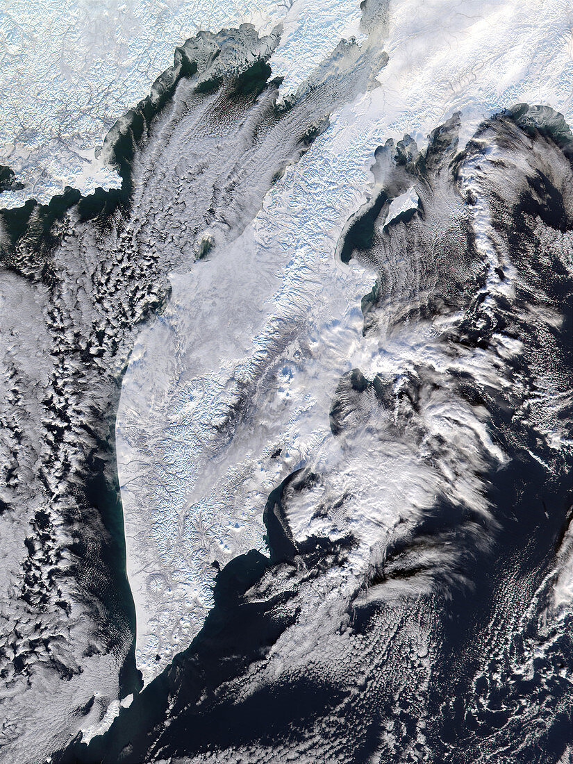
| Kamchatka Peninsula. True-colour satellite image of the Kamchatka Peninsula,north-eastern Russia,in winter. North is at top. Water is dark blue and snow,ice and clouds are white. The peninsula,bordered by the Sea of Okhotsk (left) and the Bering Sea (right),extends over 1200 kilometres from the mainland,with an area of about 518,000 square kilometres. Active volcanic mountains on the peninsula stain the ice and snow with ash (grey). The main mountain range (centre) is the Sredinnyy Khrebet,which reaches heights of 3500 metres. Image taken on 12 December 2001 by the Moderate Resolution Imaging Spectroradiometer (MODIS) aboard NASA's Terra satellite | |
| Lizenzart: | Lizenzpflichtig |
| Credit: | Science Photo Library / NASA |
| Bildgröße: | 2625 px × 3500 px |
| Modell-Rechte: | nicht erforderlich |
| Eigentums-Rechte: | nicht erforderlich |
| Restrictions: | - |
Preise für dieses Bild ab 15 €
Universitäten & Organisationen
(Informationsmaterial Digital, Informationsmaterial Print, Lehrmaterial Digital etc.)
ab 15 €
Redaktionell
(Bücher, Bücher: Sach- und Fachliteratur, Digitale Medien (redaktionell) etc.)
ab 30 €
Werbung
(Anzeigen, Aussenwerbung, Digitale Medien, Fernsehwerbung, Karten, Werbemittel, Zeitschriften etc.)
ab 55 €
Handelsprodukte
(bedruckte Textilie, Kalender, Postkarte, Grußkarte, Verpackung etc.)
ab 75 €
Pauschalpreise
Rechtepakete für die unbeschränkte Bildnutzung in Print oder Online
ab 495 €
Keywords
- 1,
- Arktis,
- Berg,
- Berge,
- Bilderwelt,
- Eis,
- eisig,
- Gefroren,
- Geographie,
- Kalt,
- Küste,
- Küsten,
- Küsten-,
- Land,
- Meer,
- modis,
- Ozean,
- Ozeane,
- Reichweite,
- Russisch,
- Russland,
- Satellitenbild,
- Schnee,
- schneebedeckt,
- Spektrometer,
- Spektroradiometer,
- Terra,
- Umwelt,
- Vulkan,
- Vulkane,
- vulkanisch,
- Wasser,
- Weltall,
- Winter,
- Wolke,
- Wolken,
- Wolkig