Forest fires,Canary Islands,July 2007
Bildnummer 11738551
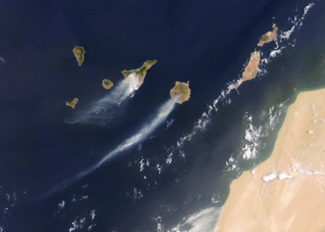
| Forest fires,Canary Islands,July 2007,satellite image. North is at top. The fires are on the two main islands at centre,Tenerife (left) and Gran Canaria (right). The smoke (grey) is being blown south-west. The African mainland is at bottom right. More than 2000 people were evacuated due to these fires. This image,covering an area some 600 kilometres across,was obtained on 30 July 2007,by the MODIS instrument on NASA's Aqua satellite | |
| Lizenzart: | Lizenzpflichtig |
| Credit: | Science Photo Library / NASA / GSFC / MODIS RAPID RESPONSE TEAM |
| Bildgröße: | 3496 px × 2497 px |
| Modell-Rechte: | nicht erforderlich |
| Eigentums-Rechte: | nicht erforderlich |
| Restrictions: | - |
Preise für dieses Bild ab 15 €
Universitäten & Organisationen
(Informationsmaterial Digital, Informationsmaterial Print, Lehrmaterial Digital etc.)
ab 15 €
Redaktionell
(Bücher, Bücher: Sach- und Fachliteratur, Digitale Medien (redaktionell) etc.)
ab 30 €
Werbung
(Anzeigen, Aussenwerbung, Digitale Medien, Fernsehwerbung, Karten, Werbemittel, Zeitschriften etc.)
ab 55 €
Handelsprodukte
(bedruckte Textilie, Kalender, Postkarte, Grußkarte, Verpackung etc.)
ab 75 €
Pauschalpreise
Rechtepakete für die unbeschränkte Bildnutzung in Print oder Online
ab 495 €
Keywords
- 21. Jahrhundert,
- Afrika,
- Afrikanisch,
- aqua,
- Atlantischer Ozean,
- atmosphärisch,
- blasend,
- Erdbeobachtung,
- Feuer,
- geografisch,
- Geographie,
- Gran Canaria,
- Hitzewelle,
- Juli,
- Kanarische Inseln,
- Katastrophe,
- Land,
- Meer,
- modis,
- Natur,
- Naturkatastrophe,
- Ozean,
- Rauch,
- saisonal,
- Satellit,
- Satellitenbild,
- Schaden,
- Sommer,
- Spektroradiometer,
- Umwelt,
- Verbrennung,
- Waldbrände,
- Weltall,
- wild,
- Wolke,
- Wüste,
- Zerstörung