Great Mississippi Flood,1927
Bildnummer 11738422
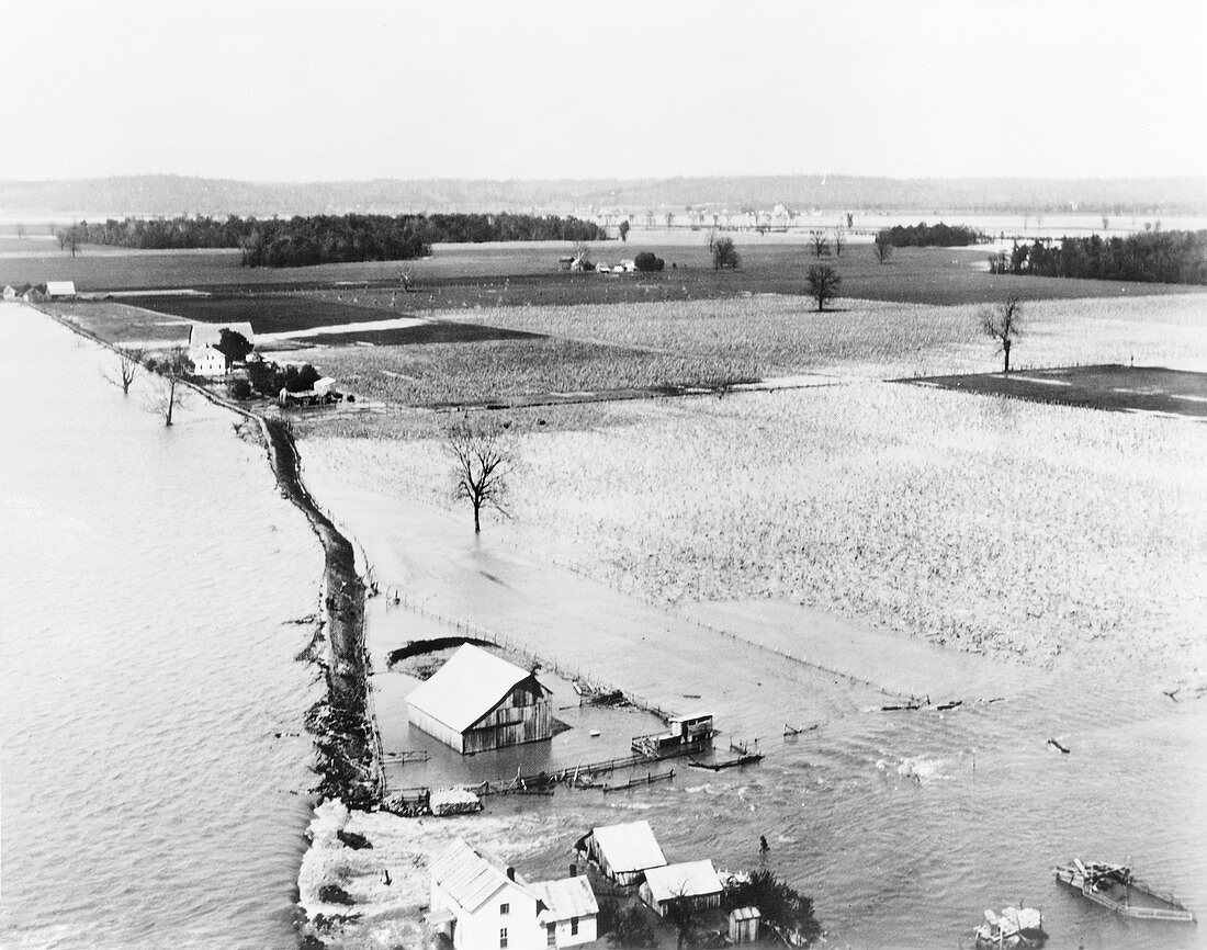
| Great Mississippi Flood,1927. Floodwater from the Mississippi River (left) flowing through a levee breach (lower left) and flooding fields near Grand Tower,Illinois,USA,in 1927. This is part of the Great Mississippi Flood of 1927,when heavy rains caused the Mississippi River to burst its banks and levees in 145 places in six states,flooding thousands of square kilometres of land up to 10 metres deep in water. This was one of the worst floods ever in the history of the USA. The Mississippi has a long history of flooding. It is one of the longest rivers in the USA,flows over 3700 kilometres north to south across the USA,and has the third largest drainage basin in the world | |
| Lizenzart: | Lizenzpflichtig |
| Credit: | Science Photo Library / Library of Congress |
| Bildgröße: | 3734 px × 2941 px |
| Modell-Rechte: | nicht erforderlich |
| Eigentums-Rechte: | nicht erforderlich |
| Restrictions: | - |
Preise für dieses Bild ab 15 €
Universitäten & Organisationen
(Informationsmaterial Digital, Informationsmaterial Print, Lehrmaterial Digital etc.)
ab 15 €
Redaktionell
(Bücher, Bücher: Sach- und Fachliteratur, Digitale Medien (redaktionell) etc.)
ab 30 €
Werbung
(Anzeigen, Aussenwerbung, Digitale Medien, Fernsehwerbung, Karten, Werbemittel, Zeitschriften etc.)
ab 55 €
Handelsprodukte
(bedruckte Textilie, Kalender, Postkarte, Grußkarte, Verpackung etc.)
ab 75 €
Pauschalpreise
Rechtepakete für die unbeschränkte Bildnutzung in Print oder Online
ab 495 €
Keywords
- 1900er Jahre,
- 20. Jahrhundert,
- Amerikanisch,
- Bauernhof,
- Einfarbig,
- Feld,
- Felder,
- Fluss,
- Flut,
- Gebäude,
- Geschichte,
- historisch,
- Illinois,
- Katastrophe,
- Klima,
- Klimatologie,
- klimatologisch,
- ländlich,
- Landschaft,
- Meteorologie,
- meteorologisch,
- Mississippi,
- Naturkatastrophe,
- Nordamerika,
- Schwarz und weiß,
- überflutet,
- Überschwemmung,
- uns,
- USA,
- Vereinigte Staaten,
- Wasser,
- Wetter