New Orleans after Hurricane Katrina
Bildnummer 11738207
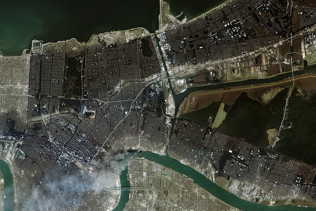
| New Orleans after Hurricane Katrina,on the 2nd September 2005,Ikonos satellite image. Flooded areas (dark blue) contrast with the dry areas (far left and lower centre). New Orleans is a city on the US Gulf coast. Lake Pontchartrain (top) is to the north of the city,and the Mississippi River (bottom) is to the south. Hurricane Katrina hit on 29th August 2005. Soon afterwards,the rise in water levels breached the levees that held back the waters of Lake Pontchartrain. One of the major breaches was in the canal at right of the large fire at lower centre. Although many people fled the city before the hurricane hit,many thousands remained and many thousands died. A complete evacuation was ordered on 30 August 2005 | |
| Lizenzart: | Lizenzpflichtig |
| Credit: | Science Photo Library / Geoeye |
| Bildgröße: | 6000 px × 4004 px |
| Modell-Rechte: | nicht erforderlich |
| Eigentums-Rechte: | nicht erforderlich |
| Restrictions: | - |
Preise für dieses Bild ab 15 €
Universitäten & Organisationen
(Informationsmaterial Digital, Informationsmaterial Print, Lehrmaterial Digital etc.)
ab 15 €
Redaktionell
(Bücher, Bücher: Sach- und Fachliteratur, Digitale Medien (redaktionell) etc.)
ab 30 €
Werbung
(Anzeigen, Aussenwerbung, Digitale Medien, Fernsehwerbung, Karten, Werbemittel, Zeitschriften etc.)
ab 55 €
Handelsprodukte
(bedruckte Textilie, Kalender, Postkarte, Grußkarte, Verpackung etc.)
ab 75 €
Pauschalpreise
Rechtepakete für die unbeschränkte Bildnutzung in Print oder Online
ab 495 €
Keywords
- 21. Jahrhundert,
- Amerikanisch,
- Beschädigt,
- Dorf,
- Erdbeobachtung,
- extrem,
- Feuer,
- Fluss,
- Flut,
- Golf von Mexiko,
- Hafen,
- IKONOS,
- Katastrophe,
- Klima,
- Klimatologie,
- klimatologisch,
- Küste,
- Küsten-,
- Louisiana,
- Meteorologie,
- meteorologisch,
- Naturkatastrophe,
- New Orleans,
- Nordamerika,
- Rauch,
- Satellit,
- Satellitenbild,
- Schaden,
- See,
- September,
- Stadt,
- überflutet,
- Überschwemmung,
- uns,
- Unterwasser,
- USA,
- Vereinigte Staaten,
- Verwüstung,
- Wasser,
- Weltall,
- Wetter,
- Zerstörung,
- zestört