Hurricane Felix,3 September 2007
Bildnummer 11738093
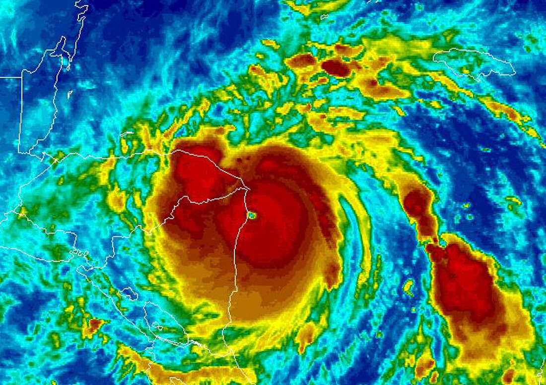
| Hurricane Felix,satellite image. North is at top. Image obtained at 11:15 GMT on 4 September 2007 as the hurricane impacted Central America (left) from the Caribbean Sea,moving east to west. The image is colour-coded,with the most destructive central part of the hurricane (red) surrounded by weaker storm clouds (yellow,green and blue). The eye is green. After the hurricane passed over the islands Bonaire and Curacao on 2 September,it increased to a category 5 hurricane with wind speeds of up to 270 kilometres per hour. It was still at its most powerful when it hit the Nicaragua-Honduras border (centre). Hurricane Felix followed less than a month after Hurricane Dean,which severely damaged Jamaica on 19 August 2007. Image from NOAA's GOES satellite | |
| Lizenzart: | Lizenzpflichtig |
| Credit: | Science Photo Library / NOAA |
| Bildgröße: | 637 px × 450 px |
| Modell-Rechte: | nicht erforderlich |
| Eigentums-Rechte: | nicht erforderlich |
| Restrictions: |
|
Preise für dieses Bild ab 15 €
Universitäten & Organisationen
(Informationsmaterial Digital, Informationsmaterial Print, Lehrmaterial Digital etc.)
ab 15 €
Redaktionell
(Bücher, Bücher: Sach- und Fachliteratur, Digitale Medien (redaktionell) etc.)
ab 30 €
Werbung
(Anzeigen, Aussenwerbung, Digitale Medien, Fernsehwerbung, Karten, Werbemittel, Zeitschriften etc.)
ab 55 €
Handelsprodukte
(bedruckte Textilie, Kalender, Postkarte, Grußkarte, Verpackung etc.)
ab 75 €
Pauschalpreise
Rechtepakete für die unbeschränkte Bildnutzung in Print oder Online
ab 495 €
Keywords
- Atlantisch,
- Auge,
- Erdbeobachtung,
- extrem,
- gefährlich,
- Honduras,
- Hurrikan,
- infrarot,
- ir,
- Karibisches Meer,
- Kategorie 5,
- Klima,
- Land,
- Landung,
- Meer,
- Meteorologie,
- meteorologisch,
- Mittelamerika,
- NASA,
- Ozean,
- Regenbogen,
- rotierend,
- Satellit,
- Satellitenbild,
- Tropisch,
- Weltall,
- Wetter,
- Wolke,
- Wolken,
- Zentralamerika