Carbon dioxide levels,Atlantic,2003
Bildnummer 11736419
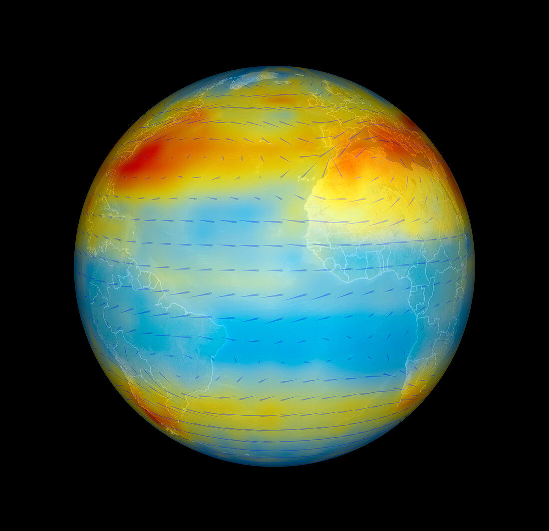
| Atmospheric carbon dioxide levels centred on the Atlantic Ocean,satellite data. Carbon dioxide (CO2) is a greenhouse gas that contributes to global warming. CO2 levels vary from low (blue,360 parts per million) through medium (yellow and orange) to high (red,385 parts per million). Wind directions (arrows) are also shown. The CO2 levels were measured in the mid-troposphere,around eight kilometres above the Earth's surface. The levels are highest above industrialised areas (Europe and North America) that produce CO2,and lowest over uninhabited or forested areas (South America and West Africa) that absorb CO2. This image is based on data acquired in July 2003 by the Atmospheric Infrared Sounder (AIRS) instrument on NASA's Aqua satellite | |
| Lizenzart: | Lizenzpflichtig |
| Credit: | Science Photo Library / JPL / GODDARD SVS / NASA |
| Bildgröße: | 2560 px × 2476 px |
| Modell-Rechte: | nicht erforderlich |
| Eigentums-Rechte: | nicht erforderlich |
| Restrictions: | - |
Preise für dieses Bild ab 15 €
Universitäten & Organisationen
(Informationsmaterial Digital, Informationsmaterial Print, Lehrmaterial Digital etc.)
ab 15 €
Redaktionell
(Bücher, Bücher: Sach- und Fachliteratur, Digitale Medien (redaktionell) etc.)
ab 30 €
Werbung
(Anzeigen, Aussenwerbung, Digitale Medien, Fernsehwerbung, Karten, Werbemittel, Zeitschriften etc.)
ab 55 €
Handelsprodukte
(bedruckte Textilie, Kalender, Postkarte, Grußkarte, Verpackung etc.)
ab 75 €
Pauschalpreise
Rechtepakete für die unbeschränkte Bildnutzung in Print oder Online
ab 495 €
Keywords
- Afrika,
- Afrikanisch,
- Amerikanisch,
- aqua,
- Atlantischer Ozean,
- Atmosphäre,
- atmosphärisch,
- Daten,
- Ebenen,
- Erdbeobachtung,
- Erde,
- Erdkunde,
- Europa,
- europäisch,
- Experiment,
- Forschung,
- Gase,
- Geowissenschaften,
- Globale Erwärmung,
- hoch,
- infrarot,
- ir,
- Juli,
- Klimatologie,
- klimatologisch,
- Klimawandel,
- Kohlendioxid,
- Konzentration,
- Konzentrationen,
- Kreislauf,
- Messung,
- Mischen,
- NASA,
- Niedrig,
- Nordamerika,
- nordamerikanisch,
- Planet,
- ppm,
- Region,
- Richtungen,
- Satellit,
- Satellitenbild,
- Südamerika,
- Südamerikanisch,
- Teile pro Million,
- Treibhausgas,
- uns,
- USA,
- Vereinigte Staaten,
- verschmutzt,
- Verschmutzung,
- Weltall,
- weltweit,
- Wissenschaften