Scandinavia
Bildnummer 11735863
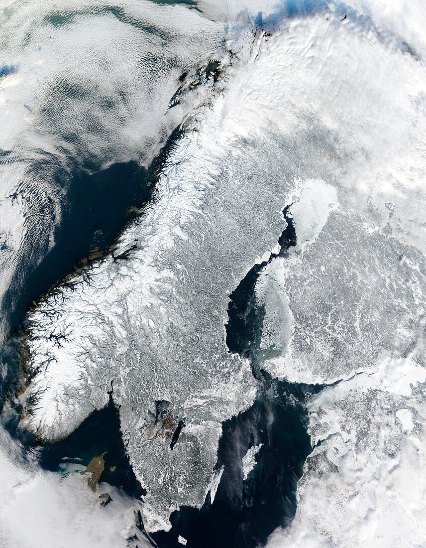
| Scandinavia,true-colour satellite image. North is at top. Water is blue and clouds,snow and ice are white. The Scandinavian Peninsula's topography is varied. The western coast was carved by glaciers in the last ice age,forming numerous deep inlets called fjords. The land rises to form the coastal mountains of Norway (white). Further inland,the snow-covered lowlands of Sweden are darkened with forests and lakes (some at lower centre). Finland lies at centre right and upper right. Estonia,Latvia and Lithuania are at lower right. Some bays of the Baltic Sea have been covered by sea ice. Photographed on 19 February 2003 by the MODIS sensor on NASA's Terra satellite | |
| Lizenzart: | Lizenzpflichtig |
| Credit: | Science Photo Library / NASA |
| Bildgröße: | 5600 px × 7200 px |
| Modell-Rechte: | nicht erforderlich |
| Eigentums-Rechte: | nicht erforderlich |
| Restrictions: | - |
Preise für dieses Bild ab 15 €
Universitäten & Organisationen
(Informationsmaterial Digital, Informationsmaterial Print, Lehrmaterial Digital etc.)
ab 15 €
Redaktionell
(Bücher, Bücher: Sach- und Fachliteratur, Digitale Medien (redaktionell) etc.)
ab 30 €
Werbung
(Anzeigen, Aussenwerbung, Digitale Medien, Fernsehwerbung, Karten, Werbemittel, Zeitschriften etc.)
ab 55 €
Handelsprodukte
(bedruckte Textilie, Kalender, Postkarte, Grußkarte, Verpackung etc.)
ab 75 €
Pauschalpreise
Rechtepakete für die unbeschränkte Bildnutzung in Print oder Online
ab 495 €
Keywords
- 1,
- baltisch,
- Berg,
- Berge,
- Bild,
- Bilder,
- Eis,
- Erdbeobachtung,
- Erdkunde,
- europäisch,
- Februar,
- Finnisch,
- Finnland,
- Fjord,
- Fjorde,
- Foto,
- Fotos,
- Gefroren,
- geografisch,
- Geographie,
- Halbinsel,
- Kalt,
- Klima,
- Land,
- Meer,
- modis,
- monochromes Bild,
- Nordeuropa,
- Nordisch,
- Norwegen,
- Ozean,
- Satellit,
- Schnee,
- Schwarz und weiß,
- Schweden,
- Schwedisch,
- Skandinavien,
- Terra,
- topografisch,
- Topographie,
- topographisch,
- Wasser,
- Weltall,
- Wetter,
- Winter,
- Wissenschaften,
- Wolke,
- Wolken,
- Wolkig