Whole Earth map
Bildnummer 11735229
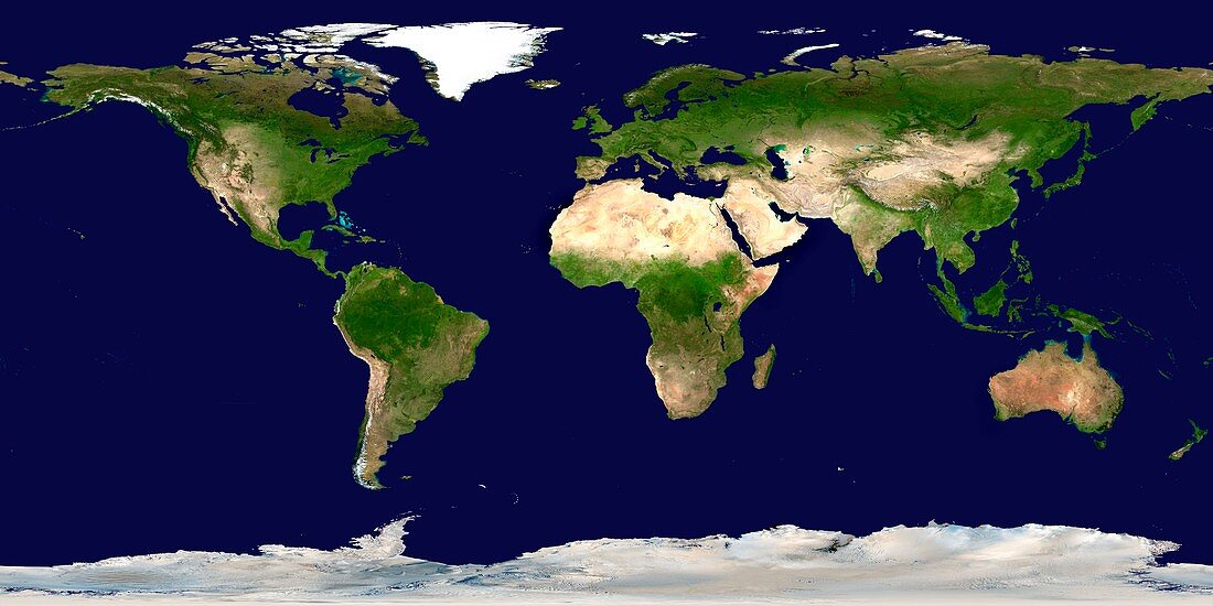
| Whole Earth map based on satellite data. This is a mosaic of numerous satellite observations of the Earth. Land colours are shaded using topographic data. The land is dominated by vegetation (green) or arid land (brown) such as the deserts of North Africa. The sea ice in the polar regions has not been shown,revealing details of the Antarctic and Arctic coasts. The surface colour of the oceans is shown. Sandy shallow seas,like the Great Bahama Bank (upper left) are light blue. This image uses cloud-free MODIS (Moderate Resolution Imaging Spectroradiometer) data from June-September 2001. Antarctica was imaged by AVHRR (Advanced Very High Resolution Radiometer) data | |
| Lizenzart: | Lizenzpflichtig |
| Credit: | Science Photo Library / NASA |
| Bildgröße: | 6500 px × 3250 px |
| Modell-Rechte: | nicht erforderlich |
| Eigentums-Rechte: | nicht erforderlich |
| Restrictions: | - |
Preise für dieses Bild ab 15 €
Universitäten & Organisationen
(Informationsmaterial Digital, Informationsmaterial Print, Lehrmaterial Digital etc.)
ab 15 €
Redaktionell
(Bücher, Bücher: Sach- und Fachliteratur, Digitale Medien (redaktionell) etc.)
ab 30 €
Werbung
(Anzeigen, Aussenwerbung, Digitale Medien, Fernsehwerbung, Karten, Werbemittel, Zeitschriften etc.)
ab 55 €
Handelsprodukte
(bedruckte Textilie, Kalender, Postkarte, Grußkarte, Verpackung etc.)
ab 75 €
Pauschalpreise
Rechtepakete für die unbeschränkte Bildnutzung in Print oder Online
ab 495 €
Keywords
- 1,
- AVHRR,
- Bild,
- Bilder,
- Bildgebung,
- Eis,
- Erde,
- Erdkunde,
- Fortgeschritten,
- Foto,
- Fotos,
- Ganze,
- geografisch,
- Geographie,
- Karte,
- Kartographie,
- Kontinent,
- Kontinente,
- Land,
- Meer,
- modis,
- Mosaik-,
- Ozean,
- Pflanzen,
- Planet,
- planetarisch,
- Projektion,
- projiziert,
- Satellit,
- Schnee,
- Spektroradiometer,
- topografisch,
- Topographie,
- Vegetation,
- Wald,
- Wasser,
- Welt,
- weltweit,
- Wissenschaften,
- wolkenfrei,
- wolkenlos,
- Wüste,
- Zusammengesetzt