Sea route in Japan,1680s
Bildnummer 11703532
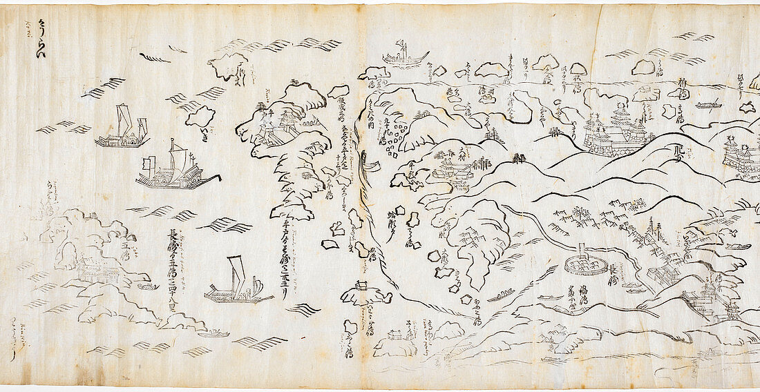
| Sea route in Japan. 17th-century map from a scroll showing part of the sea route in Japan between the cities of Edo (Tokyo) and Nagasaki. This part of the route goes from Hirado to Osaka. Hirado was the site of a British trading post. The map shows sailing ships called junks,used extensively for trade in China,Japan and the Far East. Mountains,rivers,settlements and islands are also shown. The scroll,titled 'Shokoku kairiku anken zu' (Map of the Sea Route through Various Provinces) dates from the 1680s | |
| Lizenzart: | Lizenzpflichtig |
| Credit: | Science Photo Library / British Library |
| Bildgröße: | 6907 px × 3568 px |
| Modell-Rechte: | nicht erforderlich |
| Eigentums-Rechte: | nicht erforderlich |
| Restrictions: | - |
Preise für dieses Bild ab 15 €
Universitäten & Organisationen
(Informationsmaterial Digital, Informationsmaterial Print, Lehrmaterial Digital etc.)
ab 15 €
Redaktionell
(Bücher, Bücher: Sach- und Fachliteratur, Digitale Medien (redaktionell) etc.)
ab 30 €
Werbung
(Anzeigen, Aussenwerbung, Digitale Medien, Fernsehwerbung, Karten, Werbemittel, Zeitschriften etc.)
ab 55 €
Handelsprodukte
(bedruckte Textilie, Kalender, Postkarte, Grußkarte, Verpackung etc.)
ab 75 €
Pauschalpreise
Rechtepakete für die unbeschränkte Bildnutzung in Print oder Online
ab 495 €
Keywords
- 1600er Jahre,
- 17. Jahrhundert,
- 19. Jahrhundert,
- Asiatisch,
- Asien,
- Berge,
- britisch,
- Einfarbig,
- Fernost,
- Flüsse,
- geografisch,
- Geographie,
- Geschichte,
- Handel,
- historisch,
- Illustration,
- Insel,
- Inseln,
- Japan,
- Japanisch,
- Karte,
- Karten,
- Kartographie,
- Kunstwerk,
- Maritim,
- Niemand,
- orientalisch,
- Schiffe,
- Schwarz und weiß,
- Segeln,
- Segelschiff,
- Siedlung,
- Skript,
- Transport