1930s Dust Bowl drought explained
Bildnummer 11653006
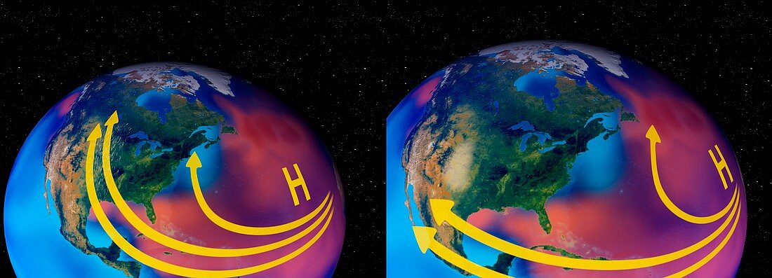
| 1930s Dust Bowl drought explained. Computer artwork showing how,during the 1930s,cooler than normal tropical Pacific Ocean temperatures (blues) and warmer than normal tropical Atlantic Ocean temperatures (red and orange) contributed to a weakened low level jet stream and changed its course,leading to a 'Dust Bowl' drought in North America. The jet stream normally flows westward over the Gulf of Mexico (lower left in each image) and then turns northward pulling up moisture and dumping rain onto the Great Plains. During the 1930s,this low level jet stream weakened,carrying less moisture,and shifted further south. The Great Plains land dried up and dust storms blew across the U.S | |
| Lizenzart: | Lizenzpflichtig |
| Credit: | Science Photo Library / NASA |
| Bildgröße: | 4943 px × 1783 px |
| Modell-Rechte: | nicht erforderlich |
| Eigentums-Rechte: | nicht erforderlich |
| Restrictions: | - |
Preise für dieses Bild ab 15 €
Universitäten & Organisationen
(Informationsmaterial Digital, Informationsmaterial Print, Lehrmaterial Digital etc.)
ab 15 €
Redaktionell
(Bücher, Bücher: Sach- und Fachliteratur, Digitale Medien (redaktionell) etc.)
ab 30 €
Werbung
(Anzeigen, Aussenwerbung, Digitale Medien, Fernsehwerbung, Karten, Werbemittel, Zeitschriften etc.)
ab 55 €
Handelsprodukte
(bedruckte Textilie, Kalender, Postkarte, Grußkarte, Verpackung etc.)
ab 75 €
Pauschalpreise
Rechtepakete für die unbeschränkte Bildnutzung in Print oder Online
ab 495 €
Keywords
- 20. Jahrhundert,
- abnormal,
- Amerikanisch,
- Atmosphäre,
- atmosphärisch,
- Bedingungen,
- cool,
- Dürre,
- Erläuterung,
- geografisch,
- Geographie,
- Geschichte,
- Golf von Mexiko,
- Great Plains,
- historisch,
- Illustration,
- Klimatologie,
- klimatologisch,
- Kondition,
- Kontinent,
- Kühler,
- Kunstwerk,
- Meteorologie,
- meteorologisch,
- Nordamerika,
- Pazifik,
- Physik,
- physisch,
- Sandsturm,
- schmutzige dreißiger Jahre,
- Stürme,
- Temperatur,
- trocken,
- Tropisch,
- Umwelt,
- Umweltwissenschaften,
- uns,
- USA,
- Vereinigte Staaten,
- Warm,
- Wetter