London,infrared satellite image
Bildnummer 11649073
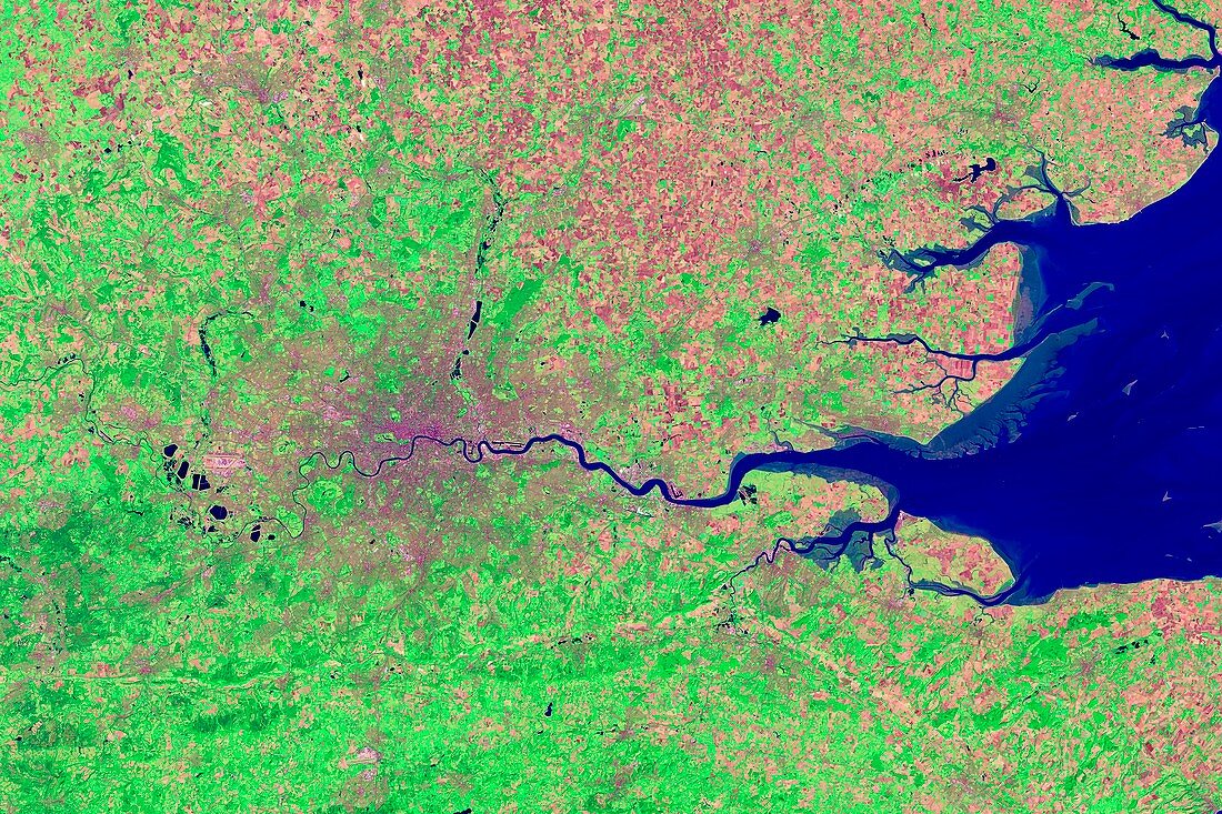
| London and its surrounds,infrared satellite image. North is at top. The Thames Estuary is at right. This view is used for geological,agricultural,and wetlands research because it can help discriminate between various rock and mineral types. Bright green spots indicate vegetation and the waters appear dark blue or black. Urban areas appear as gray or pink,while cleared fields appear tan or purple. Image data obtained on 13 September 2002 by the Enhanced Thematic Mapper Plus (bands 7,4,2) on NASA's Landsat 7 satellite. For a true-colour and an alternative infrared version of this view,see images C016/3888 and C016/3889 | |
| Lizenzart: | Lizenzpflichtig |
| Credit: | Science Photo Library / USGS / ROBERT SIMMON / NASA |
| Bildgröße: | 5152 px × 3435 px |
| Modell-Rechte: | nicht erforderlich |
| Eigentums-Rechte: | nicht erforderlich |
| Restrictions: | - |
Preise für dieses Bild ab 15 €
Universitäten & Organisationen
(Informationsmaterial Digital, Informationsmaterial Print, Lehrmaterial Digital etc.)
ab 15 €
Redaktionell
(Bücher, Bücher: Sach- und Fachliteratur, Digitale Medien (redaktionell) etc.)
ab 30 €
Werbung
(Anzeigen, Aussenwerbung, Digitale Medien, Fernsehwerbung, Karten, Werbemittel, Zeitschriften etc.)
ab 55 €
Handelsprodukte
(bedruckte Textilie, Kalender, Postkarte, Grußkarte, Verpackung etc.)
ab 75 €
Pauschalpreise
Rechtepakete für die unbeschränkte Bildnutzung in Print oder Online
ab 495 €
Keywords
- 21. Jahrhundert,
- Bodennutzung,
- britisch,
- Dorf,
- England,
- Englisch,
- Erdbeobachtung,
- etm,
- etm Plus,
- Europa,
- europäisch,
- Felder,
- Flüsse,
- geografisch,
- Geographie,
- Großbritannien,
- größte,
- Hauptstadt,
- infrarot,
- ir,
- Kent,
- Küste,
- Land,
- ländlich,
- Landsat 7,
- Landschaft,
- London,
- menschliche Geografie,
- Middlesex,
- Region,
- Reihenfolge,
- Satellit,
- Satellitenbild,
- Serie,
- Stadt,
- Städte,
- städtisch,
- Südostengland,
- Surrey,
- Themse,
- Umfeld,
- Vereinigtes Königreich,
- Weltall