London,true-colour satellite image
Bildnummer 11649071
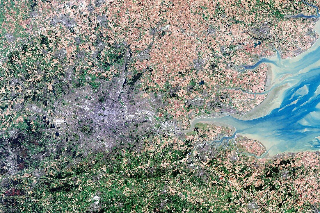
| London and its surrounds,true-colour satellite image. North is at top. The Thames Estuary is at right. London is the capital city of the UK. It has been the largest and most populous city in Europe since the 17th century,and is a major financial and cultural centre. The centre of London is at centre left,with the Thames flowing through it towards the estuary. The area shown here is around 170 kilometres across,and includes extensive areas of fields. Image data obtained on 13 September 2002 by the Enhanced Thematic Mapper Plus (bands 3,2,1) on NASA's Landsat 7 satellite. For infrared versions of this view,see images C016/3889 and C016/3890 | |
| Lizenzart: | Lizenzpflichtig |
| Credit: | Science Photo Library / USGS / ROBERT SIMMON / NASA |
| Bildgröße: | 5152 px × 3435 px |
| Modell-Rechte: | nicht erforderlich |
| Eigentums-Rechte: | nicht erforderlich |
| Restrictions: | - |
Preise für dieses Bild ab 15 €
Universitäten & Organisationen
(Informationsmaterial Digital, Informationsmaterial Print, Lehrmaterial Digital etc.)
ab 15 €
Redaktionell
(Bücher, Bücher: Sach- und Fachliteratur, Digitale Medien (redaktionell) etc.)
ab 30 €
Werbung
(Anzeigen, Aussenwerbung, Digitale Medien, Fernsehwerbung, Karten, Werbemittel, Zeitschriften etc.)
ab 55 €
Handelsprodukte
(bedruckte Textilie, Kalender, Postkarte, Grußkarte, Verpackung etc.)
ab 75 €
Pauschalpreise
Rechtepakete für die unbeschränkte Bildnutzung in Print oder Online
ab 495 €
Keywords
- 21. Jahrhundert,
- Bodennutzung,
- britisch,
- Dorf,
- England,
- Englisch,
- Erdbeobachtung,
- etm,
- etm Plus,
- Europa,
- europäisch,
- Felder,
- Flüsse,
- geografisch,
- Geographie,
- Großbritannien,
- größte,
- Hauptstadt,
- Kent,
- Küste,
- Land,
- ländlich,
- Landsat 7,
- Landschaft,
- London,
- menschliche Geografie,
- Middlesex,
- natürlich,
- Region,
- Reihenfolge,
- Satellit,
- Satellitenbild,
- Serie,
- Stadt,
- Städte,
- städtisch,
- Südostengland,
- Surrey,
- Themse,
- Umfeld,
- Vereinigtes Königreich,
- Weltall