Gulf of Mexico oil spill,satellite image
Bildnummer 11584690
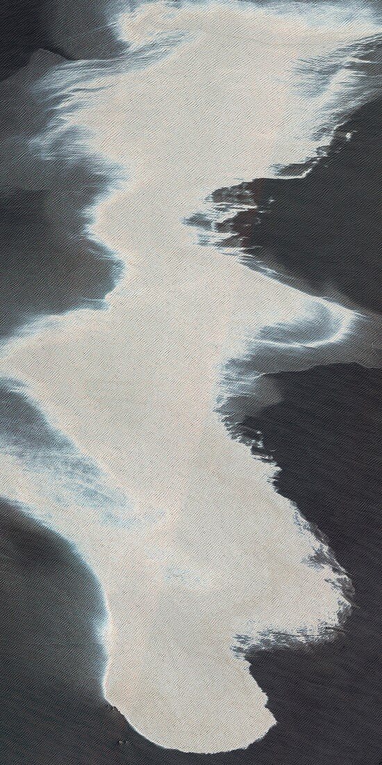
| Gulf of Mexico oil spill. Satellite image of an oil spill (white area) in the Gulf of Mexico. This spill followed a blowout that caused an explosion on the mobile offshore drilling unit Deepwater Horizon,which then sank off the coast of Louisiana. The oil spill,originating from the blowout 1,500 metres below sea level,is releasing an estimated 42,000 gallons (160,000 litres) of oil into the sea each day. Image captured by the Moderate Resolution Imaging Spectroradiometer (MODIS) on NASA’s Aqua satellite,and the Advanced Land Imager on NASA's Earth Observing satellite,on 25th April 2010 | |
| Lizenzart: | Lizenzpflichtig |
| Credit: | Science Photo Library / NASA |
| Bildgröße: | 2304 px × 4609 px |
| Modell-Rechte: | nicht erforderlich |
| Eigentums-Rechte: | nicht erforderlich |
| Restrictions: | - |
Preise für dieses Bild ab 15 €
Universitäten & Organisationen
(Informationsmaterial Digital, Informationsmaterial Print, Lehrmaterial Digital etc.)
ab 15 €
Redaktionell
(Bücher, Bücher: Sach- und Fachliteratur, Digitale Medien (redaktionell) etc.)
ab 30 €
Werbung
(Anzeigen, Aussenwerbung, Digitale Medien, Fernsehwerbung, Karten, Werbemittel, Zeitschriften etc.)
ab 55 €
Handelsprodukte
(bedruckte Textilie, Kalender, Postkarte, Grußkarte, Verpackung etc.)
ab 75 €
Pauschalpreise
Rechtepakete für die unbeschränkte Bildnutzung in Print oder Online
ab 495 €