Eyjafjallajokull eruption,April 2010
Bildnummer 11576433
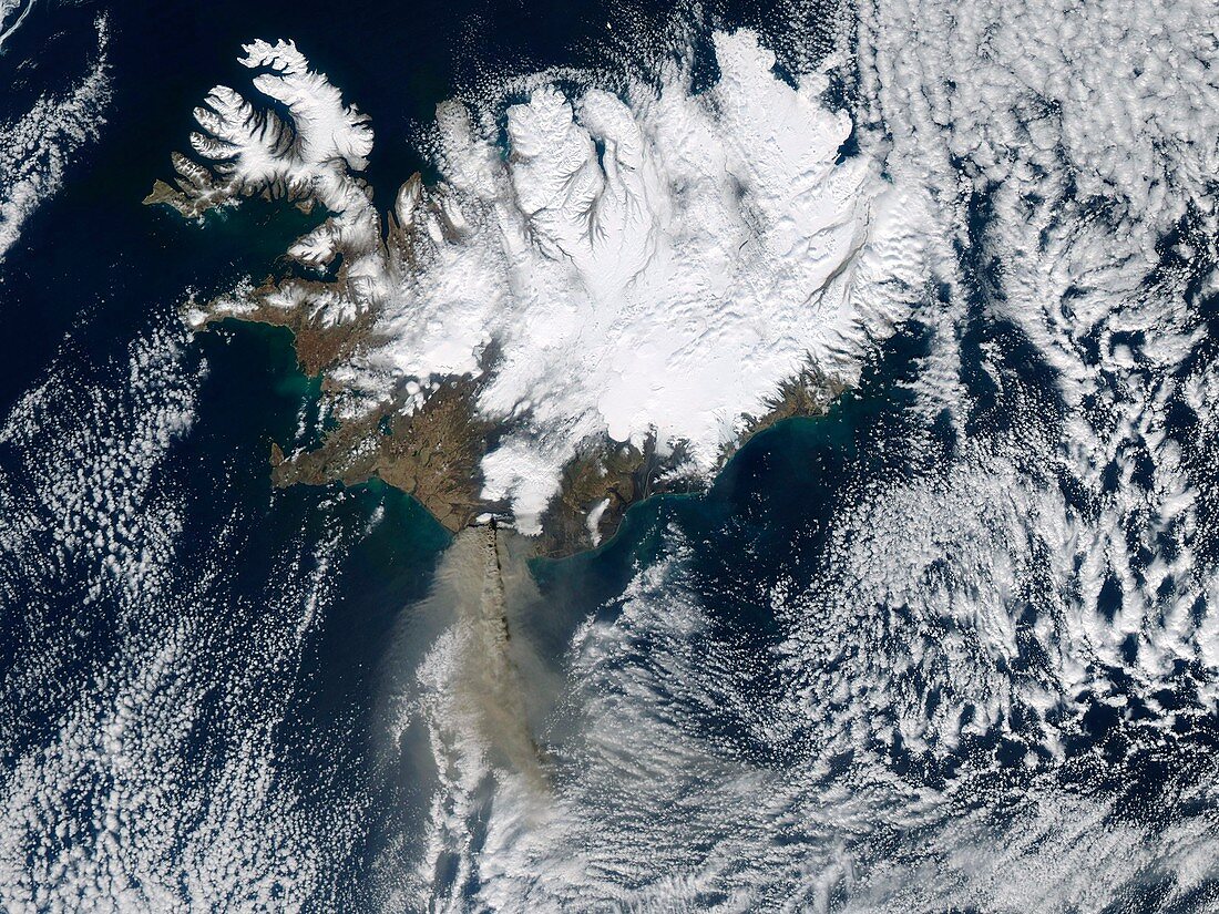
| Eyjafjallajokull eruption. Satellite image of the ash plume (grey,lower left) from the April 2010 Eyjafjallajokull eruption. The whole of Iceland (top) is shown,with North at top. Cloud and snow and ice are white. The volcano erupted below the Eyjafjallajokull glacier in southern Iceland on 14 April,sending ash high into the atmosphere. The ash was then blown south and east by the wind over the following days,leading to the airspace over the UK and other northern European countries being shut down due to the hazard the ash posed to aircraft engines. This image was obtained at 13:20 UTC on 17 April 2010,by NASA's Aqua satellite | |
| Lizenzart: | Lizenzpflichtig |
| Credit: | Science Photo Library / NASA |
| Bildgröße: | 4835 px × 3626 px |
| Modell-Rechte: | nicht erforderlich |
| Eigentums-Rechte: | nicht erforderlich |
| Restrictions: | - |
Preise für dieses Bild ab 15 €
Universitäten & Organisationen
(Informationsmaterial Digital, Informationsmaterial Print, Lehrmaterial Digital etc.)
ab 15 €
Redaktionell
(Bücher, Bücher: Sach- und Fachliteratur, Digitale Medien (redaktionell) etc.)
ab 30 €
Werbung
(Anzeigen, Aussenwerbung, Digitale Medien, Fernsehwerbung, Karten, Werbemittel, Zeitschriften etc.)
ab 55 €
Handelsprodukte
(bedruckte Textilie, Kalender, Postkarte, Grußkarte, Verpackung etc.)
ab 75 €
Pauschalpreise
Rechtepakete für die unbeschränkte Bildnutzung in Print oder Online
ab 495 €
Keywords
- 2010,
- 21. Jahrhundert,
- April,
- aqua,
- Asche,
- britisch,
- Erdbeobachtung,
- Erdkunde,
- Eruption,
- Europa,
- europäisch,
- Eyjafjallajokull,
- Flugzeug,
- Flugzeuge,
- Gefahr,
- gefährlich,
- Geologie,
- geologisch,
- Geschlossen,
- Großbritannien,
- Island,
- Isländisch,
- Luftfahrt,
- Luftraum,
- modis,
- Natur,
- Plume,
- Risiko,
- Satellit,
- Satellitenbild,
- Tephra,
- Transport,
- Vereinigtes Königreich,
- Vulkan,
- Vulkanausbruch,
- vulkanisch,
- Vulkanologie,
- Weltall,
- Wolke,
- Wolken,
- Wolkig