Global temperatures,May 2009
Bildnummer 11565164
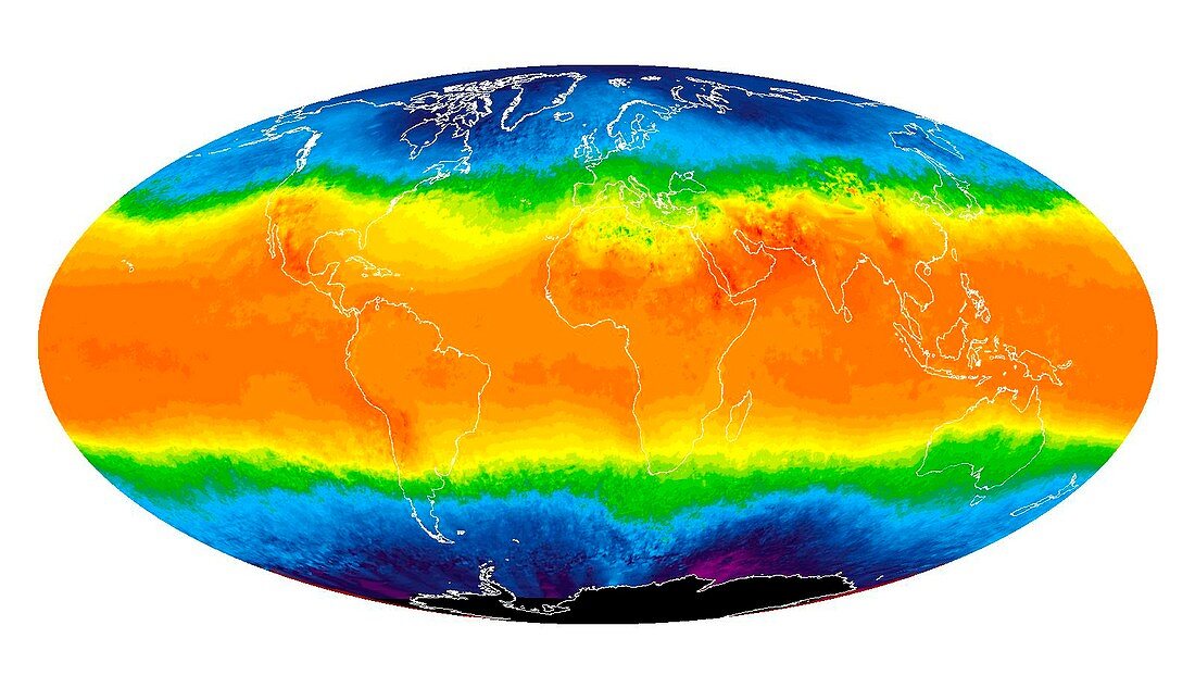
| Global temperatures,May 2009. Infrared satellite map of average daytime air temperatures at 3000 metres elevation worldwide in May 2009. The colour-coded map shows temperatures in degrees Celsius,ranging from 40 degrees Celsius (dark orange) down to minus 30 degrees Celsius (purple). Features seen here include warm tropical areas,milder temperate regions (yellow and green),and cold polar regions. The data was obtained by the AIRS (Atmospheric Infrared Sounder) instrument as part of the EOS (Earth Observing System) mission,on NASA's Aqua satellite | |
| Lizenzart: | Lizenzpflichtig |
| Credit: | Science Photo Library / NASA / JPL |
| Bildgröße: | 3898 px × 2244 px |
| Modell-Rechte: | nicht erforderlich |
| Eigentums-Rechte: | nicht erforderlich |
| Restrictions: | - |
Preise für dieses Bild ab 15 €
Universitäten & Organisationen
(Informationsmaterial Digital, Informationsmaterial Print, Lehrmaterial Digital etc.)
ab 15 €
Redaktionell
(Bücher, Bücher: Sach- und Fachliteratur, Digitale Medien (redaktionell) etc.)
ab 30 €
Werbung
(Anzeigen, Aussenwerbung, Digitale Medien, Fernsehwerbung, Karten, Werbemittel, Zeitschriften etc.)
ab 55 €
Handelsprodukte
(bedruckte Textilie, Kalender, Postkarte, Grußkarte, Verpackung etc.)
ab 75 €
Pauschalpreise
Rechtepakete für die unbeschränkte Bildnutzung in Print oder Online
ab 495 €
Keywords
- 21. Jahrhundert,
- aqua,
- Atmosphäre,
- ausgeschnitten,
- Ausschnitte,
- Blütezeit,
- cool,
- einfrieren,
- Erde,
- Erdkunde,
- Frühling,
- Gefroren,
- geografisch,
- Geographie,
- Globale Erwärmung,
- Hagedorn,
- heiß,
- infrarot,
- Kalt,
- Klimatologie,
- klimatologisch,
- Klimawandel,
- Kontinent,
- Kontinente,
- Land,
- Luft,
- Meer,
- Meteorologie,
- meteorologisch,
- Mollweide-Projektion,
- Ozean,
- Ozeane,
- Planet,
- planetarisch,
- polar,
- Satellit,
- Satellitenbild,
- temperent,
- Thermografie,
- Thermogramm,
- Tropen,
- tropisch,
- Umwelt,
- Umweltwissenschaften,
- Warm,
- Wasser,
- Weltall,
- weltweit,
- Wetter