Hurricane Erin,3-D computer image
Bildnummer 11562315
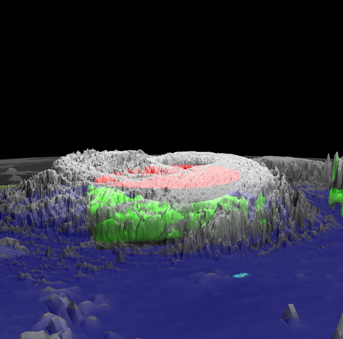
| Hurricane Erin. 3-D computer image of Hurricane Erin on 10th September 2001. This image is composed of data from several instruments. Heat (red) was measured by the Convection and Moisture Experiment (CAMEX) aboard aircraft that flew over and around the hurricane. Rain intensity and distribution (green) was measured by the precipitation radar aboard the Tropical Rainfall Measuring Mission (TRMM) satellite. The clouds (middle top) were measured by infrared detectors aboard the Geostationary Operational Environmental Satellite (GOES)and TRMM. This data was processed by supercomputers at NASA to produce a 3-D animation | |
| Lizenzart: | Lizenzpflichtig |
| Credit: | Science Photo Library / NASA |
| Bildgröße: | 4000 px × 3945 px |
| Modell-Rechte: | nicht erforderlich |
| Eigentums-Rechte: | nicht erforderlich |
| Restrictions: | - |
Preise für dieses Bild ab 15 €
Universitäten & Organisationen
(Informationsmaterial Digital, Informationsmaterial Print, Lehrmaterial Digital etc.)
ab 15 €
Redaktionell
(Bücher, Bücher: Sach- und Fachliteratur, Digitale Medien (redaktionell) etc.)
ab 30 €
Werbung
(Anzeigen, Aussenwerbung, Digitale Medien, Fernsehwerbung, Karten, Werbemittel, Zeitschriften etc.)
ab 55 €
Handelsprodukte
(bedruckte Textilie, Kalender, Postkarte, Grußkarte, Verpackung etc.)
ab 75 €
Pauschalpreise
Rechtepakete für die unbeschränkte Bildnutzung in Print oder Online
ab 495 €
Keywords
- 21. Jahrhundert,
- 3-d,
- 3D,
- 3D-Modell,
- Amerikanisch,
- Computervisualisierung,
- Erdbeobachtung,
- Erin,
- extremes Wetter,
- Hurrikan,
- infrarot,
- ir,
- Klimatologie,
- klimatologisch,
- Meteorologie,
- meteorologisch,
- NASA,
- Naturkatastrophe,
- Nordamerika,
- Ozean,
- Raum,
- Regen,
- Satellit,
- Satellitenbild,
- Supercomputersimulation,
- TRMM,
- USA,
- Vereinigte Staaten,
- Weltraumflug,
- Wetter,
- Wolke,
- Zyklon