Warham Camp, UK, 3D LiDAR scan
Bildnummer 14179864
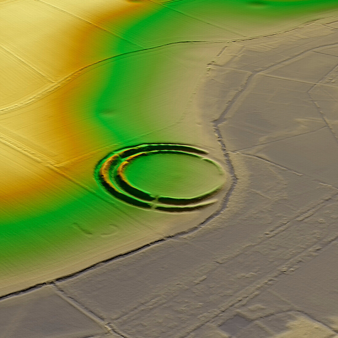
| 3D LiDAR scan of Warham Camp in Norfolk, UK. This digital terrain model reveals the site hidden by foliage and the disrupted pattern of the landscape. This ancient hillfort is one of many found across the UK and dates back to the Iron Age, roughly between 700 BC and 43 AD. These hillforts served as fortified settlements or defensive structures for ancient communities, offering protection and strategic control over the surrounding territory. Warham Camp is a circular structure with an overall diameter of 212 metres. Iron Age and Roman pottery sherds have been recovered in the site. Image contains UK public sector information licensed under the Open Government Licence v3.0. | |
| Lizenzart: | Lizenzpflichtig |
| Credit: | Science Photo Library / Terrey, Simon |
| Bildgröße: | 5905 px × 5905 px |
| Modell-Rechte: | nicht erforderlich |
| Eigentums-Rechte: | nicht erforderlich |
| Restrictions: | - |
Preise für dieses Bild ab 15 €
Universitäten & Organisationen
(Informationsmaterial Digital, Informationsmaterial Print, Lehrmaterial Digital etc.)
ab 15 €
Redaktionell
(Bücher, Bücher: Sach- und Fachliteratur, Digitale Medien (redaktionell) etc.)
ab 30 €
Werbung
(Anzeigen, Aussenwerbung, Digitale Medien, Fernsehwerbung, Karten, Werbemittel, Zeitschriften etc.)
ab 55 €
Handelsprodukte
(bedruckte Textilie, Kalender, Postkarte, Grußkarte, Verpackung etc.)
ab 75 €
Pauschalpreise
Rechtepakete für die unbeschränkte Bildnutzung in Print oder Online
ab 495 €
Keywords
- 3D,
- Alter,
- Archäologie,
- archäologisch,
- britisch,
- Digitales Geländemodell,
- Dreidimensional,
- dtm,
- England,
- Englisch,
- Erbe,
- Europa,
- europäisch,
- Geschichte,
- Großbritannien,
- historisch,
- Karte,
- Kultur,
- kulturell,
- Landschaft,
- Laser,
- Mittelalterlich,
- Modell-,
- Modelling,
- Monument,
- Niemand,
- Norfolk,
- Scan,
- Terrain,
- topografisch,
- Topographie,
- topographisch,
- Vereinigtes Königreich,
- Wall