Stonehenge and surrounding area, 3D LiDAR scan
Bildnummer 14167720
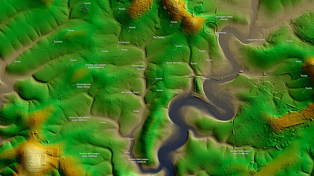
| 3D LiDAR scan of Stonehenge in Wiltshire, UK. The digital terrain model offers a wide-field view of the surrounding landscape without obstruction from foliage. It also showcases the various tumuli (mounds of earth) in the vicinity of the site. Image contains UK public sector information licensed under the Open Government Licence v3.0. | |
| Lizenzart: | Lizenzpflichtig |
| Credit: | Science Photo Library / Terrey, Simon |
| Bildgröße: | 6084 px × 3422 px |
| Modell-Rechte: | nicht erforderlich |
| Eigentums-Rechte: | nicht erforderlich |
| Restrictions: | - |
Preise für dieses Bild ab 15 €
Universitäten & Organisationen
(Informationsmaterial Digital, Informationsmaterial Print, Lehrmaterial Digital etc.)
ab 15 €
Redaktionell
(Bücher, Bücher: Sach- und Fachliteratur, Digitale Medien (redaktionell) etc.)
ab 30 €
Werbung
(Anzeigen, Aussenwerbung, Digitale Medien, Fernsehwerbung, Karten, Werbemittel, Zeitschriften etc.)
ab 55 €
Handelsprodukte
(bedruckte Textilie, Kalender, Postkarte, Grußkarte, Verpackung etc.)
ab 75 €
Pauschalpreise
Rechtepakete für die unbeschränkte Bildnutzung in Print oder Online
ab 495 €
Keywords
- 3D,
- Alter,
- Archäologie,
- archäologisch,
- Aussicht,
- beschriftet,
- britisch,
- Bronzezeit,
- Digitales Geländemodell,
- Dreidimensional,
- dtm,
- England,
- Englisch,
- Etikette,
- Etiketten,
- Europa,
- europäisch,
- Geschichte,
- Großbritannien,
- historisch,
- Hügel,
- Karte,
- Kultur,
- kulturell,
- Landschaft,
- Laser,
- Modell-,
- Modelling,
- Monument,
- neolithisch,
- Niemand,
- prähistorisch,
- Scan,
- Terrain,
- Text,
- topografisch,
- Topographie,
- topographisch,
- Unesco,
- Vereinigtes Königreich,
- Vorgeschichte,
- Weltkulturerbe,
- Wiltshire