Earthquake damage in Turkey, February 2023
Bildnummer 13742533
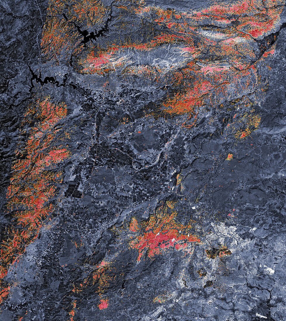
| Damage proxy map of southern Turkey showing damage caused by earthquakes on the 6th February 2023. Red areas are those that are likely to have severe damage to buildings and infrastructure. Orange areas are likely to have moderate damage, while in yellow areas there will likely be partial damage. Two earthquakes struck the area. The first, at magnitude 7.8, had a shallow depth that meant it produced violent shaking and that its effects were felt hundreds of kilometres from the epicentre. The second quake, nine hours later, had a magnitude 7.5. The two quakes caused widespread destruction and massive loss of life in southern Turkey and western Syria. Over 35, 000 people were killed, tens of thousands were injured and over 5 million people were displaced. Data collected by the Phased-Array L-band Synthetic Aperture Radar-2 (PALSAR-2) on the Advanced Land Observing Satellite-2 (ALOS-2) on 8th February 2023. | |
| Lizenzart: | Lizenzpflichtig |
| Credit: | Science Photo Library / JAXA / US Geological Survey / NASA Earth Observatory |
| Bildgröße: | 5580 px × 6269 px |
| Modell-Rechte: | nicht erforderlich |
| Eigentums-Rechte: | nicht erforderlich |
| Restrictions: | - |
Preise für dieses Bild ab 15 €
Universitäten & Organisationen
(Informationsmaterial Digital, Informationsmaterial Print, Lehrmaterial Digital etc.)
ab 15 €
Redaktionell
(Bücher, Bücher: Sach- und Fachliteratur, Digitale Medien (redaktionell) etc.)
ab 30 €
Werbung
(Anzeigen, Aussenwerbung, Digitale Medien, Fernsehwerbung, Karten, Werbemittel, Zeitschriften etc.)
ab 55 €
Handelsprodukte
(bedruckte Textilie, Kalender, Postkarte, Grußkarte, Verpackung etc.)
ab 75 €
Pauschalpreise
Rechtepakete für die unbeschränkte Bildnutzung in Print oder Online
ab 495 €