The Richat Structure, Mauritania, satellite image
Bildnummer 12540240
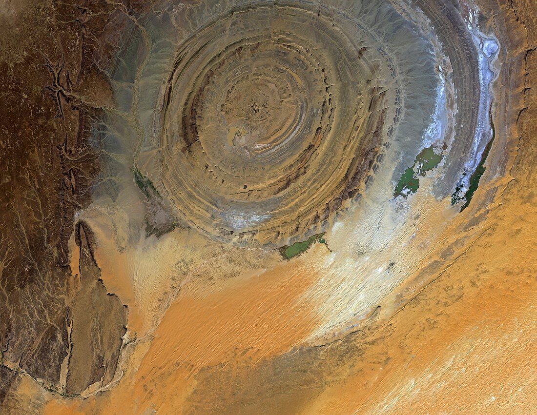
| The Richat Structure in the Sahara Desert, satellite image. The Richat Structure is 40 kilometres across and was originally thought to be a meteorite impact crater. More recent analysis has led to the conclusion that the Structure was an uplifted dome of rock, subsequent erosion of the 'roof' of the dome having exposed this cross-sectional 'slice' through the various layers. The Richat Structure is in Mauritania, and was first photographed from space from a Gemini spacecraft in 1965. This image was acquired on 23 November 2010 by the Advanced Visible and Near Infrared Radiometer on Japan's ALOS satellite. | |
| Lizenzart: | Lizenzpflichtig |
| Credit: | Science Photo Library / JAXA / ESA |
| Bildgröße: | 4942 px × 3823 px |
| Modell-Rechte: | nicht erforderlich |
| Eigentums-Rechte: | nicht erforderlich |
| Restrictions: |
|
Preise für dieses Bild ab 15 €
Universitäten & Organisationen
(Informationsmaterial Digital, Informationsmaterial Print, Lehrmaterial Digital etc.)
ab 15 €
Redaktionell
(Bücher, Bücher: Sach- und Fachliteratur, Digitale Medien (redaktionell) etc.)
ab 30 €
Werbung
(Anzeigen, Aussenwerbung, Digitale Medien, Fernsehwerbung, Karten, Werbemittel, Zeitschriften etc.)
ab 55 €
Handelsprodukte
(bedruckte Textilie, Kalender, Postkarte, Grußkarte, Verpackung etc.)
ab 75 €
Pauschalpreise
Rechtepakete für die unbeschränkte Bildnutzung in Print oder Online
ab 495 €
Keywords
- 2010,
- 21. Jahrhundert,
- Abstrakt,
- Afrika,
- Afrikanisch,
- Erdbeobachtung,
- Erde aus dem Weltraum,
- geografisch,
- Geographie,
- Geologie,
- geologisch,
- Gestalt,
- Internationale Raumstation,
- ISS,
- Japan,
- Japanisch,
- jaxa,
- Konzepte,
- Kreis,
- kreisförmig,
- Kuppel,
- Mauretanien,
- rund,
- Satellit,
- Satellitenbild,
- Weltraumflug