2018 Great Britain and Ireland cold wave, satellite image
Bildnummer 12489769
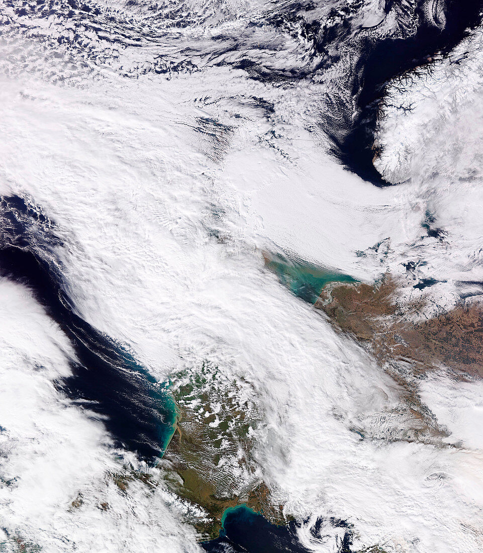
| 2018 Great Britain and Ireland cold wave, satellite image. North is at top. The United Kingdom (UK) and Ireland are at upper centre, covered in clouds and snow and ice due to a cold front that had arrived from the east. Disruption to the normal weather patterns resulted in a large anticyclonic air mass (an Arctic outbreak) forming over Europe and Asia, bringing cold air from Russia and Siberia to Europe. This broke cold weather records for March for the UK, with further disruption over the following days due to Storm Emma (centre left). This image was obtained by the VIIRS (Visible Infrared Imaging Radiometer Suite) instrument on the NOAA-20 weather satellite at around 12:23 UTC on 2 March 2018. For a sequence of satellite images of this weather event over three days, see C038/4157 to C038/4159. | |
| Lizenzart: | Lizenzpflichtig |
| Credit: | Science Photo Library / University of Dundee |
| Bildgröße: | 3493 px × 4000 px |
| Modell-Rechte: | nicht erforderlich |
| Eigentums-Rechte: | nicht erforderlich |
| Restrictions: | - |
Preise für dieses Bild ab 15 €
Universitäten & Organisationen
(Informationsmaterial Digital, Informationsmaterial Print, Lehrmaterial Digital etc.)
ab 15 €
Redaktionell
(Bücher, Bücher: Sach- und Fachliteratur, Digitale Medien (redaktionell) etc.)
ab 30 €
Werbung
(Anzeigen, Aussenwerbung, Digitale Medien, Fernsehwerbung, Karten, Werbemittel, Zeitschriften etc.)
ab 55 €
Handelsprodukte
(bedruckte Textilie, Kalender, Postkarte, Grußkarte, Verpackung etc.)
ab 75 €
Pauschalpreise
Rechtepakete für die unbeschränkte Bildnutzung in Print oder Online
ab 495 €