Mount Erebus, Antarctica, satellite image
Bildnummer 12420521
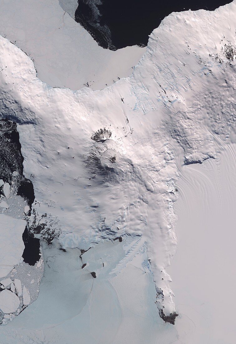
| Mount Erebus, Antarctica, satellite image. North is towards upper left. This volcano (3794 metres) is one of four volcanoes on Ross Island off the coast of Antarctica. It is the second-highest volcano in Antarctica, and the most southerly active volcano on Earth. Features seen on this image include the summit crater (centre), the Erebus ice tongue (lower centre), and Scott Base and McMurdo Station at the tip of the peninsula at lower right. This image covers an area around 45 kilometres across. Image data (combining infrared and visible light) obtained on 31 December 2013, by the ASTER (Advanced Spaceborne Thermal Emission and Reflection Radiometer) sensor on NASA's Terra satellite. | |
| Lizenzart: | Lizenzpflichtig |
| Credit: | Science Photo Library / US-Japan ASTER Science Team / JAROS / ERSDAC / METI / GSFC / NASA EARTH OBSERVATORY |
| Bildgröße: | 3457 px × 5022 px |
| Modell-Rechte: | nicht erforderlich |
| Eigentums-Rechte: | nicht erforderlich |
| Restrictions: | - |
Preise für dieses Bild ab 15 €
Universitäten & Organisationen
(Informationsmaterial Digital, Informationsmaterial Print, Lehrmaterial Digital etc.)
ab 15 €
Redaktionell
(Bücher, Bücher: Sach- und Fachliteratur, Digitale Medien (redaktionell) etc.)
ab 30 €
Werbung
(Anzeigen, Aussenwerbung, Digitale Medien, Fernsehwerbung, Karten, Werbemittel, Zeitschriften etc.)
ab 55 €
Handelsprodukte
(bedruckte Textilie, Kalender, Postkarte, Grußkarte, Verpackung etc.)
ab 75 €
Pauschalpreise
Rechtepakete für die unbeschränkte Bildnutzung in Print oder Online
ab 495 €
Keywords
- 1,
- 2013,
- 21. Jahrhundert,
- Antarktis,
- Aster,
- Berg,
- Eis,
- Erdbeobachtung,
- geografisch,
- Geologie,
- geologisch,
- Geowissenschaften,
- Glaziologie,
- infrarot,
- ir,
- Land,
- McMurdo Station,
- Meer,
- Meereis,
- Niemand,
- optisch,
- Ross Island,
- Satellit,
- Satellitenbild,
- Schnee,
- Sichtbar,
- Terra,
- Vulkan,
- vulkanisch,
- Vulkanologie,
- Weltall