Virunga Mountains, East Africa, satellite image
Bildnummer 12325556
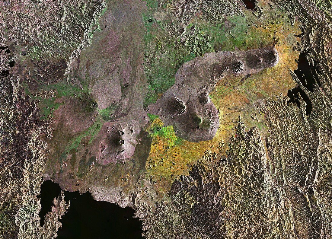
| Virunga Mountains. Radar composite satellite image of the Virunga Mountains in East Africa, with part of Lake Kivu visible (black, lower left). This chain of volcanos lies on the Albertine Rift and stretches across Rwanda's northern border with Uganda, and east into the Democratic Republic of the Congo. While most are dormant, two of the eight volcanoes are active, with the most recent eruptions in 2006 and 2010. Imaged by the Sentinel-1 satellite, in November 2016. | |
| Lizenzart: | Lizenzpflichtig |
| Credit: | Science Photo Library / ESA / Copernicus Sentinel data (2016) |
| Bildgröße: | 9658 px × 6957 px |
| Modell-Rechte: | nicht erforderlich |
| Eigentums-Rechte: | nicht erforderlich |
| Restrictions: |
|
Preise für dieses Bild ab 15 €
Universitäten & Organisationen
(Informationsmaterial Digital, Informationsmaterial Print, Lehrmaterial Digital etc.)
ab 15 €
Redaktionell
(Bücher, Bücher: Sach- und Fachliteratur, Digitale Medien (redaktionell) etc.)
ab 30 €
Werbung
(Anzeigen, Aussenwerbung, Digitale Medien, Fernsehwerbung, Karten, Werbemittel, Zeitschriften etc.)
ab 55 €
Handelsprodukte
(bedruckte Textilie, Kalender, Postkarte, Grußkarte, Verpackung etc.)
ab 75 €
Pauschalpreise
Rechtepakete für die unbeschränkte Bildnutzung in Print oder Online
ab 495 €
Keywords
- 2016,
- 21. Jahrhundert,
- Afrikanisch,
- aktiv,
- Berg,
- Berge,
- bergig,
- Erdbeobachtung,
- gebirgig,
- geografisch,
- Geographie,
- Geologie,
- geologisch,
- Gipfel,
- Große Seen,
- Niemand,
- November,
- Ostafrika,
- Ruanda,
- Ruhend,
- Satellitenbild,
- Sentinel-1,
- Stratovulkan,
- Uganda,
- ugandisch,
- Umwelt,
- Umweltwissenschaften,
- Vulkan,
- Vulkane,
- vulkanisch,
- Vulkanologie,
- Wasser,
- Weltall,
- Zusammengesetzt