Gravity anomaly map of Mars
Bildnummer 12098810
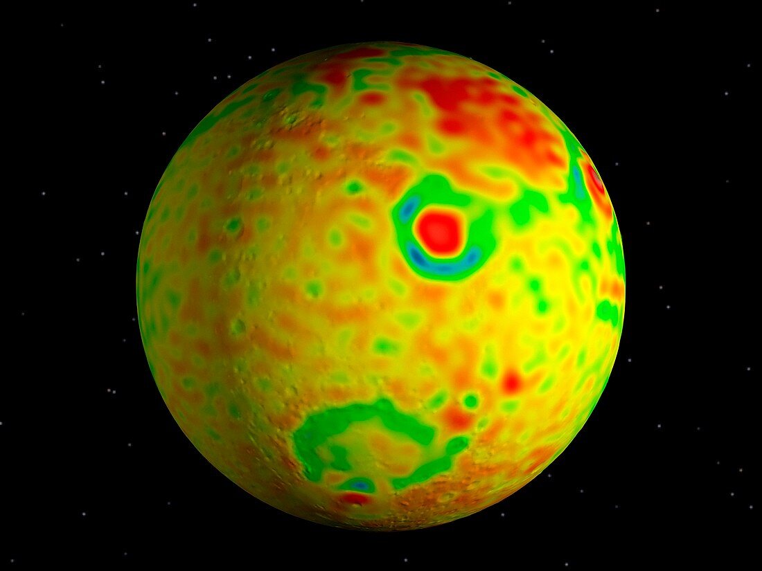
| Gravity anomaly map of Mars. Vertical gravity map of Mars colour-coded in milligals (mGal) based on radio tracking,overlaid on a global topography map from the Mars Orbiter Laser Altimeter (MOLA). The comparison shows where the map lacks correlations with the gravity anomalies. The MOLA data was obtained by the orbiting Mars Global Surveyor (MGS) Orbiter. This map was created using MGS data by the MGS Radio Science Team,based at Stanford University in Palo Alto,California,USA. The image was published in 2001 | |
| Lizenzart: | Lizenzpflichtig |
| Credit: | Science Photo Library / NASA / JPL |
| Bildgröße: | 3411 px × 2558 px |
| Modell-Rechte: | nicht erforderlich |
| Eigentums-Rechte: | nicht erforderlich |
| Restrictions: | - |
Preise für dieses Bild ab 15 €
Universitäten & Organisationen
(Informationsmaterial Digital, Informationsmaterial Print, Lehrmaterial Digital etc.)
ab 15 €
Redaktionell
(Bücher, Bücher: Sach- und Fachliteratur, Digitale Medien (redaktionell) etc.)
ab 30 €
Werbung
(Anzeigen, Aussenwerbung, Digitale Medien, Fernsehwerbung, Karten, Werbemittel, Zeitschriften etc.)
ab 55 €
Handelsprodukte
(bedruckte Textilie, Kalender, Postkarte, Grußkarte, Verpackung etc.)
ab 75 €
Pauschalpreise
Rechtepakete für die unbeschränkte Bildnutzung in Print oder Online
ab 495 €
Keywords
- Astronomie,
- astronomisch,
- Astrophysik,
- astrophysikalisch,
- Ball,
- farbcodiert,
- Globus,
- Gravitation,
- Gravitations-,
- Kugel,
- kugelförmig,
- Mars,
- Mars Global Surveyor,
- MGS,
- Mola,
- Niemand,
- Planet,
- planetarisch,
- Planetenwissenschaft,
- Radio,
- Raum,
- Satellitenbild,
- schwarzer Hintergrund,
- Sonnensystem,
- vom Mars,
- Weltall