Rosaccio world map,1643
Bildnummer 11946502
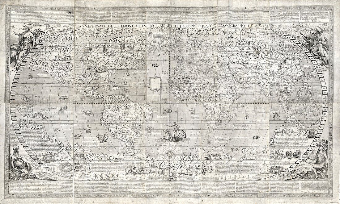
| Rosaccio world map. 17th-century world map by Italian cartographer Giuseppe Rosaccio (c.1530-c.1620). First produced in 1597,this is thought to be the second state of 1643. The four corners contain allegorical figures and the principal cities of the four continents: Europe,Africa,Asia and the New World (the Americas). Neptune is at lower centre. Illustrations and Italian notes on geography and ethnography across top and bottom,and in the vast unknown southern continent,mention the French in Florida and the English in Virginia. Explorers on the oceans include Walter Raleigh,Christopher Columbus,Marco Polo,Vasco da Gama and Ferdinand Magellan | |
| Lizenzart: | Lizenzpflichtig |
| Credit: | Science Photo Library / LIBRARY OF CONGRESS, Geography and Map Division |
| Bildgröße: | 5926 px × 3560 px |
| Modell-Rechte: | nicht erforderlich |
| Eigentums-Rechte: | nicht erforderlich |
| Restrictions: | - |
Preise für dieses Bild ab 15 €
Universitäten & Organisationen
(Informationsmaterial Digital, Informationsmaterial Print, Lehrmaterial Digital etc.)
ab 15 €
Redaktionell
(Bücher, Bücher: Sach- und Fachliteratur, Digitale Medien (redaktionell) etc.)
ab 30 €
Werbung
(Anzeigen, Aussenwerbung, Digitale Medien, Fernsehwerbung, Karten, Werbemittel, Zeitschriften etc.)
ab 55 €
Handelsprodukte
(bedruckte Textilie, Kalender, Postkarte, Grußkarte, Verpackung etc.)
ab 75 €
Pauschalpreise
Rechtepakete für die unbeschränkte Bildnutzung in Print oder Online
ab 495 €
Keywords
- 1500er Jahre,
- 16. Jahrhundert,
- 1600er Jahre,
- 17. Jahrhundert,
- Afrika,
- Afrikanisch,
- Allegorische Figuren,
- Asiatisch,
- Asien,
- Atlantischer Ozean,
- Christopher Columbus,
- Einfarbig,
- Erde,
- Erkundung,
- Europa,
- europäisch,
- Florida,
- geografisch,
- Geographie,
- Geschichte,
- historisch,
- Illustration,
- illustriert,
- Indischer Ozean,
- Italienisch,
- Karte,
- Kartographie,
- Kolonien,
- Kontinent,
- Kontinente,
- Kunstwerk,
- Marco Polo,
- Neptun,
- Neue Welt,
- Niemand,
- Nordamerika,
- nordamerikanisch,
- Ozeane,
- Pazifik,
- Schiffe,
- Schwarz und weiß,
- Stadt,
- Städte,
- Südamerika,
- Südamerikanisch,
- Terra Australis,
- Text,
- Vasco da Gama,
- Virginia,
- Walter Raleigh,
- Weltkarte