Fluvial erosion on Mars
Bildnummer 11882458
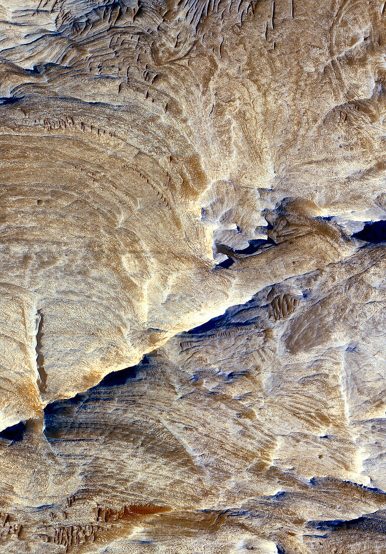
| Fluvial erosion on Mars. Satellite image of the Candor Chasma region of the Valles Marineris canyon. It is thought that this canyon initially formed as the result of tectonic fracturing of the upper crust of Mars. The ridged areas on the valley floor are intepretated as being joints that were exposed during subsequent fluvial erosion (erosion by flowing water). This image was obtained by the High Resolution Imaging Science Experiment (HiRise) camera on board the Mars Reconnaissance Orbiter,December 2,2006 | |
| Lizenzart: | Lizenzpflichtig |
| Credit: | Science Photo Library / NASA / JPL / University of Arizona |
| Bildgröße: | 2486 px × 3567 px |
| Modell-Rechte: | nicht erforderlich |
| Eigentums-Rechte: | nicht erforderlich |
| Restrictions: | - |
Preise für dieses Bild ab 15 €
Universitäten & Organisationen
(Informationsmaterial Digital, Informationsmaterial Print, Lehrmaterial Digital etc.)
ab 15 €
Redaktionell
(Bücher, Bücher: Sach- und Fachliteratur, Digitale Medien (redaktionell) etc.)
ab 30 €
Werbung
(Anzeigen, Aussenwerbung, Digitale Medien, Fernsehwerbung, Karten, Werbemittel, Zeitschriften etc.)
ab 55 €
Handelsprodukte
(bedruckte Textilie, Kalender, Postkarte, Grußkarte, Verpackung etc.)
ab 75 €
Pauschalpreise
Rechtepakete für die unbeschränkte Bildnutzung in Print oder Online
ab 495 €
Keywords
- 21. Jahrhundert,
- Astronomie,
- Dezember,
- erodiert,
- Erosion,
- Fraktur,
- Gelenk,
- Geologie,
- geologisch,
- Geomorphologie,
- Grat,
- HiRISE,
- hochauflösende Bildgebung,
- Hydrologie,
- Joint,
- Kosmologie,
- Mars,
- MRO,
- NASA,
- Planet,
- planetarisch,
- Planetenwissenschaft,
- Raum,
- Satellit,
- Satellitenbild,
- Schichten,
- Schlucht,
- Sonnensystem,
- Tal,
- Terrain,
- Valles Marineris,
- vom Mars,
- Wasser,
- Weltall,
- Wissenschaft