Topographic map of the surface of Venus
Bildnummer 11881699
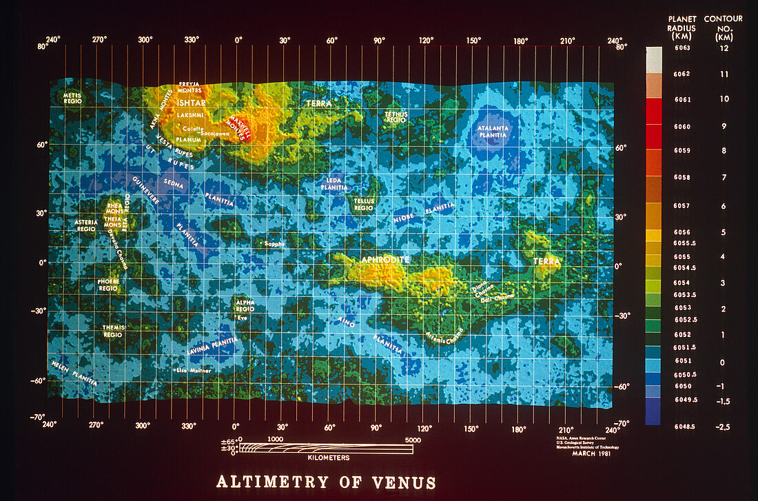
| Colour-coded topographic map of the surface of Venus compiled from radar data recorded by the Pioneer-Venus spacecraft. Most of the planet's surface is covered by relatively smooth plains,coloured in shades of blue in this image. Occasional depressions & basins descend up to 3 km below the mean level of the plains and cover about 16% of the surface. Highland regions are coloured green and yellow,with the highest mountain ranges in orange & red. The Maxwell Montes,in the Ishtar Terra highland region (upper left),contain the highest mountain on Venus,rising 11 km above the mean surface level | |
| Lizenzart: | Lizenzpflichtig |
| Credit: | Science Photo Library / NASA |
| Bildgröße: | 5284 px × 3491 px |
| Modell-Rechte: | nicht erforderlich |
| Eigentums-Rechte: | nicht erforderlich |
| Restrictions: | - |
Preise für dieses Bild ab 15 €
Universitäten & Organisationen
(Informationsmaterial Digital, Informationsmaterial Print, Lehrmaterial Digital etc.)
ab 15 €
Redaktionell
(Bücher, Bücher: Sach- und Fachliteratur, Digitale Medien (redaktionell) etc.)
ab 30 €
Werbung
(Anzeigen, Aussenwerbung, Digitale Medien, Fernsehwerbung, Karten, Werbemittel, Zeitschriften etc.)
ab 55 €
Handelsprodukte
(bedruckte Textilie, Kalender, Postkarte, Grußkarte, Verpackung etc.)
ab 75 €
Pauschalpreise
Rechtepakete für die unbeschränkte Bildnutzung in Print oder Online
ab 495 €