Gaza City
Bildnummer 11748777
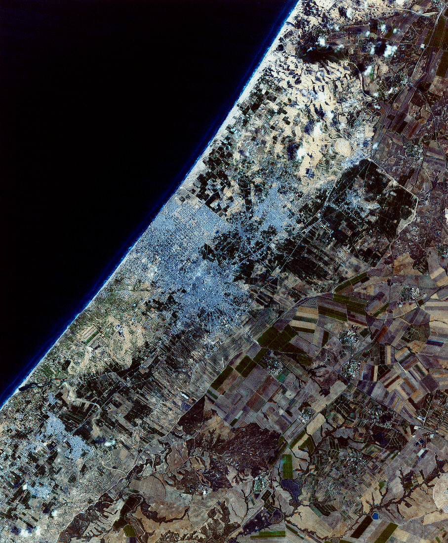
| Gaza City,satellite image. North is at top. Water is dark blue,vegetation is green,barren land is brown and urban areas are grey. The centre of Gaza City (centre) lies inland from the coastal suburbs bordering the Mediterranean Sea (upper left). The surrounding area contains cultivated fields (green rectangles) and desert areas (brown). Gaza City is the principal city of the Gaza Strip,currently a semi-autonomous area of Israel. This 20-kilometre- wide image combines a panchromatic SPOT satellite image (8 December 1994) and a Landsat satellite Thematic Mapper (TM) image (3 August 1992) | |
| Lizenzart: | Lizenzpflichtig |
| Credit: | Science Photo Library / MDA Information Systems |
| Bildgröße: | 3167 px × 3840 px |
| Modell-Rechte: | nicht erforderlich |
| Eigentums-Rechte: | nicht erforderlich |
| Restrictions: | - |
Preise für dieses Bild ab 15 €
Universitäten & Organisationen
(Informationsmaterial Digital, Informationsmaterial Print, Lehrmaterial Digital etc.)
ab 15 €
Redaktionell
(Bücher, Bücher: Sach- und Fachliteratur, Digitale Medien (redaktionell) etc.)
ab 30 €
Werbung
(Anzeigen, Aussenwerbung, Digitale Medien, Fernsehwerbung, Karten, Werbemittel, Zeitschriften etc.)
ab 55 €
Handelsprodukte
(bedruckte Textilie, Kalender, Postkarte, Grußkarte, Verpackung etc.)
ab 75 €
Pauschalpreise
Rechtepakete für die unbeschränkte Bildnutzung in Print oder Online
ab 495 €
Keywords
- Anbau,
- August,
- Bauernhof,
- Bauernhöfe,
- Bodennutzung,
- Dezember,
- Feld,
- Felder,
- geografisch,
- Geographie,
- Israel,
- Israelisch,
- Jüdisch,
- kultiviert,
- Küste,
- Küsten-,
- Küstenlinie,
- Landwirtschaft,
- landwirtschaftlich,
- Mittelmeer,
- Mittlerer Osten,
- optisch,
- Palästina,
- Satellit,
- Sichtbar,
- Stadt,
- Städte,
- städtisch,
- Stelle,
- Strand,
- Strände,
- Streifen,
- Tm,
- Urbanisierung,
- Wasser,
- Weltall