Eastern Himalayas,satellite image
Bildnummer 11744755
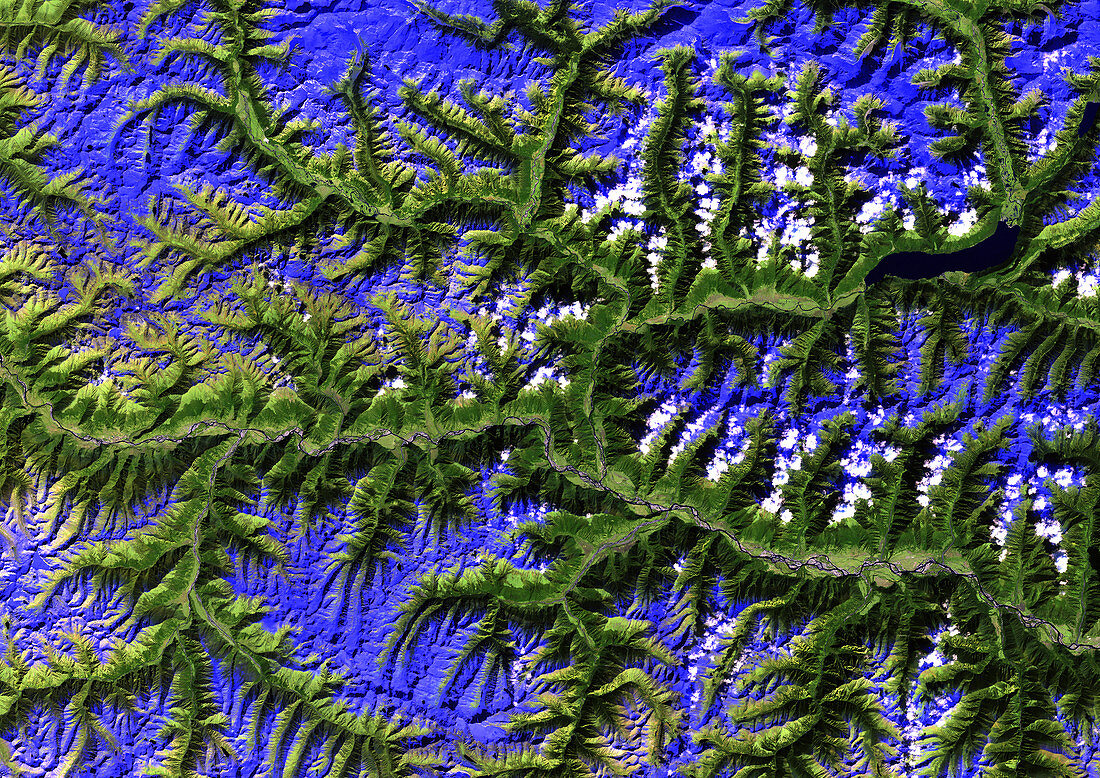
| Eastern Himalayas,satellite image. North is at top. Cloud cover is white. The snow-capped peaks are dark blue,the lower slopes are covered by vegetation (dark green). Areas of barren earth (including the valley bottom) are light green. A large lake is at top right (indigo). This image has been achieved using thematic mapper (TM) instrumentation. The TM sensor collects radiometric data in seven spectral bands. Each band gathers particular information on different surface features. The bands are combined to achieve a particular image. This image was achieved using Bands: 3,for discrimination of vegetation types,5,to differentiate between cloud and snow and for determination of soil and vegetation moisture content,and 7,for discrimination of rock types. These bands have a spectral range of 0.63 to 2.35 micrometres | |
| Lizenzart: | Lizenzpflichtig |
| Credit: | Science Photo Library / Planetobserver |
| Bildgröße: | 4961 px × 3508 px |
| Modell-Rechte: | nicht erforderlich |
| Eigentums-Rechte: | nicht erforderlich |
| Restrictions: | - |
Preise für dieses Bild ab 15 €
Universitäten & Organisationen
(Informationsmaterial Digital, Informationsmaterial Print, Lehrmaterial Digital etc.)
ab 15 €
Redaktionell
(Bücher, Bücher: Sach- und Fachliteratur, Digitale Medien (redaktionell) etc.)
ab 30 €
Werbung
(Anzeigen, Aussenwerbung, Digitale Medien, Fernsehwerbung, Karten, Werbemittel, Zeitschriften etc.)
ab 55 €
Handelsprodukte
(bedruckte Textilie, Kalender, Postkarte, Grußkarte, Verpackung etc.)
ab 75 €
Pauschalpreise
Rechtepakete für die unbeschränkte Bildnutzung in Print oder Online
ab 495 €
Keywords
- 21. Jahrhundert,
- Asiatisch,
- Asien,
- Aster,
- Berg,
- Berge,
- bergig,
- Bergkette,
- China,
- Chinesisch,
- eisig,
- Erdbeobachtung,
- Erdkunde,
- farbig,
- Fluss,
- gebirgig,
- gefärbt,
- Gefroren,
- geografisch,
- Geographie,
- Geologie,
- geologisch,
- Himalaya,
- infrarot,
- ir,
- Land,
- montan,
- Natur,
- Reflexionsradiometer,
- Satellit,
- Satellitenbild,
- See,
- Tal,
- Terra,
- Tm,
- Umwelt,
- Vegetation,
- Wald,
- Wasser,
- Weltall,
- Winter