San Gabriel Mountains,USA
Bildnummer 11744721
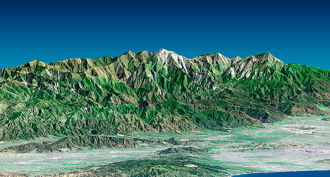
| San Gabriel mountains. True-colour radar-generated image looking north-east from the Mailbu coastline towards the San Gabriel mountains,California,USA. Vegetation is green,urban areas are grey and water is blue. At bottom right is the Pacific Ocean. On its coast at right is downtown Los Angeles,with Santa Monica to its left. In the foreground at left is the San Fernando Valley,separated from the ocean by the Santa Monica mountains. The highest peak in the San Gabriel mountains is Mount San Antonio (white capped) at 3,068 metres tall. It is commonly known as Mount Baldy. Image obtained by draping visual Landsat 7 satellite data over topographical radar data from the Shuttle Radar Topography Mission (SRTM). Topographic expression is exaggerated one and a half times | |
| Lizenzart: | Lizenzpflichtig |
| Credit: | Science Photo Library / NASA |
| Bildgröße: | 3430 px × 1845 px |
| Modell-Rechte: | nicht erforderlich |
| Eigentums-Rechte: | nicht erforderlich |
| Restrictions: | - |
Preise für dieses Bild ab 15 €
Universitäten & Organisationen
(Informationsmaterial Digital, Informationsmaterial Print, Lehrmaterial Digital etc.)
ab 15 €
Redaktionell
(Bücher, Bücher: Sach- und Fachliteratur, Digitale Medien (redaktionell) etc.)
ab 30 €
Werbung
(Anzeigen, Aussenwerbung, Digitale Medien, Fernsehwerbung, Karten, Werbemittel, Zeitschriften etc.)
ab 55 €
Handelsprodukte
(bedruckte Textilie, Kalender, Postkarte, Grußkarte, Verpackung etc.)
ab 75 €
Pauschalpreise
Rechtepakete für die unbeschränkte Bildnutzung in Print oder Online
ab 495 €
Keywords
- 3-d,
- 3-dimensional,
- Amerikanisch,
- Berg,
- Berge,
- Bergkette,
- Computergrafik,
- Erdbeobachtung,
- geografisch,
- Geographie,
- Illustration,
- Kalifornien,
- Kunstwerk,
- Küste,
- Küsten-,
- Küstenlinie,
- Landsat 7,
- Linderung,
- Los Angeles,
- Nordamerika,
- nordamerikanisch,
- Pazifik,
- Santa Monica,
- Satellit,
- Satellitenbild,
- Stadt,
- städtisch,
- topografisch,
- topographisch,
- Umwelt,
- uns,
- USA,
- Vegetation,
- Vereinigte Staaten,
- Wasser,
- Weltall,
- Zusammengesetzt