Garlock fault
Bildnummer 11740384
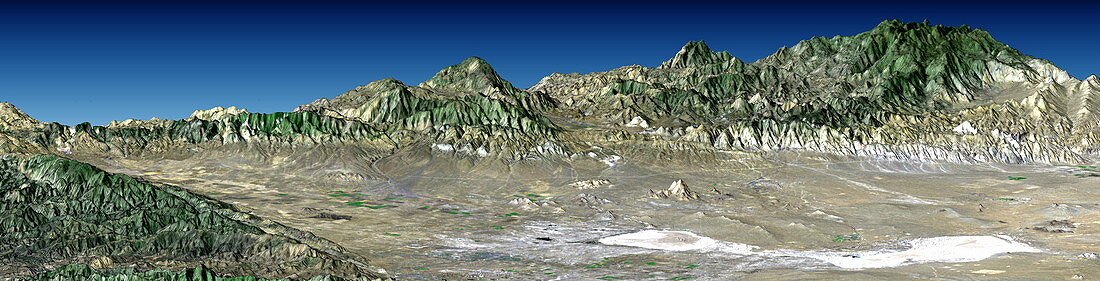
| Garlock fault. True-colour radar-generated image looking north-west,over Antelope Valley,towards the Garlock fault,California,USA. This fault is marked by the mountains running across the image. Together with the San Andreas fault (bottom left corner of the image),it bounds this valley that forms the westernmost part of the Mojave Desert. Rosamund and Rogers dry lakes (white) are at lower right. The active Garlock and San Andreas faults cause major earthquakes in the region. This image was obtained by draping visual Landsat satellite data over topographical radar data from the Shuttle Radar Topography Mission (SRTM,Space Shuttle Endeavour,February 2000) | |
| Lizenzart: | Lizenzpflichtig |
| Credit: | Science Photo Library / NASA |
| Bildgröße: | 3069 px × 785 px |
| Modell-Rechte: | nicht erforderlich |
| Eigentums-Rechte: | nicht erforderlich |
| Restrictions: | - |
Preise für dieses Bild ab 15 €
Universitäten & Organisationen
(Informationsmaterial Digital, Informationsmaterial Print, Lehrmaterial Digital etc.)
ab 15 €
Redaktionell
(Bücher, Bücher: Sach- und Fachliteratur, Digitale Medien (redaktionell) etc.)
ab 30 €
Werbung
(Anzeigen, Aussenwerbung, Digitale Medien, Fernsehwerbung, Karten, Werbemittel, Zeitschriften etc.)
ab 55 €
Handelsprodukte
(bedruckte Textilie, Kalender, Postkarte, Grußkarte, Verpackung etc.)
ab 75 €
Pauschalpreise
Rechtepakete für die unbeschränkte Bildnutzung in Print oder Online
ab 495 €
Keywords
- 2000,
- Amerika,
- Amerikanisch,
- Berg,
- Berge,
- Erdbeben,
- Geographie,
- Geologie,
- geologisch,
- Grenze,
- Kalifornien,
- Land,
- Mission,
- Panorama-,
- Raum,
- Rogers,
- San Andreas,
- Satellit,
- See,
- Seen,
- Seismologie,
- SRTM,
- topografisch,
- topographisch,
- Trocken,
- uns,
- USA,
- Vereinigte Staaten