3-D map of the ocean floor around Los Angeles,USA
Bildnummer 11740224
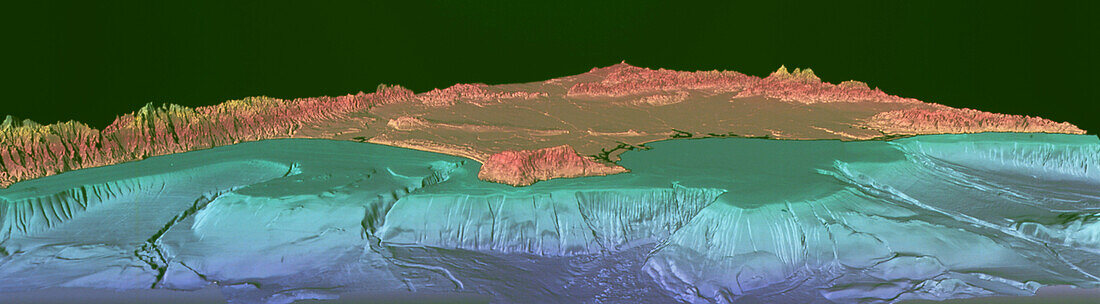
| Los Angeles sea floor. Coloured three-dimensional image of the ocean floor topography around Los Angeles,California,USA. North is towards top left. Areas below sea level are blue/green,those above it are pink. This map was made using multi- beam bathymetry,a form of ship-borne sonar,in which sound is reflected off the sea bed. The shallow continental shelf (green) extends from the land to the abrupt drop of the continental slope. These mapping techniques may be used for tracking toxic waste migration and for studying submarine earthquake faults. Los Angeles occupies the region behind the San Pedro Peninsula (centre). San Pedro Bay is at right,with Santa Monica Bay at left | |
| Lizenzart: | Lizenzpflichtig |
| Credit: | Science Photo Library / US Geological Survey |
| Bildgröße: | 6413 px × 1772 px |
| Modell-Rechte: | nicht erforderlich |
| Eigentums-Rechte: | nicht erforderlich |
| Restrictions: | - |
Preise für dieses Bild ab 15 €
Universitäten & Organisationen
(Informationsmaterial Digital, Informationsmaterial Print, Lehrmaterial Digital etc.)
ab 15 €
Redaktionell
(Bücher, Bücher: Sach- und Fachliteratur, Digitale Medien (redaktionell) etc.)
ab 30 €
Werbung
(Anzeigen, Aussenwerbung, Digitale Medien, Fernsehwerbung, Karten, Werbemittel, Zeitschriften etc.)
ab 55 €
Handelsprodukte
(bedruckte Textilie, Kalender, Postkarte, Grußkarte, Verpackung etc.)
ab 75 €
Pauschalpreise
Rechtepakete für die unbeschränkte Bildnutzung in Print oder Online
ab 495 €