Indonesian coastline,after 2004 tsunami
Bildnummer 11739828
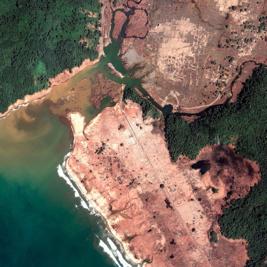
| After tsunami. Image 2 of 2. Satellite image of the Indonesian coastline,near Gleebruk,on 2 January 2005. The lowland areas have been stripped bare and covered in mud by huge waves (tsunamis) from a massive earthquake,the world's largest for 40 years,that struck on 26 December 2004. It took place underwater some 160 kilometres to the west. Severe coastal erosion is seen,the river shape is changed and the outlines of fields and the coastal road is all that remains,along with the forests on high ground. Over 150,000 died in Indonesia and round the Indian Ocean. Quickbird satellite image. Pre-tsunami image is E275/039 | |
| Lizenzart: | Lizenzpflichtig |
| Credit: | Science Photo Library / Digital Globe, Eurimage |
| Bildgröße: | 2675 px × 2674 px |
| Modell-Rechte: | nicht erforderlich |
| Eigentums-Rechte: | nicht erforderlich |
| Restrictions: |
|
Preise für dieses Bild ab 15 €
Universitäten & Organisationen
(Informationsmaterial Digital, Informationsmaterial Print, Lehrmaterial Digital etc.)
ab 15 €
Redaktionell
(Bücher, Bücher: Sach- und Fachliteratur, Digitale Medien (redaktionell) etc.)
ab 30 €
Werbung
(Anzeigen, Aussenwerbung, Digitale Medien, Fernsehwerbung, Karten, Werbemittel, Zeitschriften etc.)
ab 55 €
Handelsprodukte
(bedruckte Textilie, Kalender, Postkarte, Grußkarte, Verpackung etc.)
ab 75 €
Pauschalpreise
Rechtepakete für die unbeschränkte Bildnutzung in Print oder Online
ab 495 €
Keywords
- Abholzung,
- Asiatisch,
- Asien,
- Bauernhof,
- Bauernhöfe,
- Bäume,
- bewaldet,
- Dezember,
- Dorf,
- Dörfer,
- Erdbeben,
- Erdbeobachtung,
- erodiert,
- Erosion,
- Feld,
- Felder,
- Fluss,
- Flutwelle,
- Gleebruk,
- Indischer Ozean,
- Indonesien,
- Indonesisch,
- Januar,
- Katastrophe,
- Küste,
- Küsten-,
- Küstenlinie,
- ländlich,
- Landschaft,
- natürlich,
- Reihenfolge,
- Satellit,
- Satellitenbild,
- Schaden,
- seismische Aktivität,
- Seismologie,
- Strand,
- Strände,
- Straße,
- Südostasien,
- Sumatra,
- Tod,
- Tsunami,
- Ufer,
- Wald,
- Weltall,
- Zerstörung,
- zestört