World at night
Bildnummer 11736003
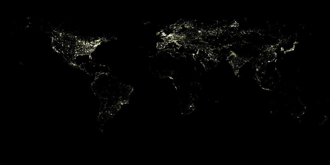
| World at night. Satellite map showing the world at night. Lights show areas of human population,with brightly lit areas marking dense urban populations (large cities). The dark areas include remote and undeveloped areas,and also uninhabited areas such as deserts,forests and oceans. The brightest and most urbanised areas are in North America (upper left),Europe (upper centre),and Japan and South Korea (upper right). Most of South America (lower left),Africa (centre) and Australia (lower right) are dark,as are the polar regions and large areas of Asia. Other well-lit areas include large cities in China,India,South-East Asia,the Middle East and Russia. For this map in the day,see E050/585 | |
| Lizenzart: | Lizenzpflichtig |
| Credit: | Science Photo Library / Planetobserver |
| Bildgröße: | 4961 px × 2480 px |
| Modell-Rechte: | nicht erforderlich |
| Eigentums-Rechte: | nicht erforderlich |
| Restrictions: | - |
Preise für dieses Bild ab 15 €
Universitäten & Organisationen
(Informationsmaterial Digital, Informationsmaterial Print, Lehrmaterial Digital etc.)
ab 15 €
Redaktionell
(Bücher, Bücher: Sach- und Fachliteratur, Digitale Medien (redaktionell) etc.)
ab 30 €
Werbung
(Anzeigen, Aussenwerbung, Digitale Medien, Fernsehwerbung, Karten, Werbemittel, Zeitschriften etc.)
ab 55 €
Handelsprodukte
(bedruckte Textilie, Kalender, Postkarte, Grußkarte, Verpackung etc.)
ab 75 €
Pauschalpreise
Rechtepakete für die unbeschränkte Bildnutzung in Print oder Online
ab 495 €
Keywords
- Afrika,
- Afrikanisch,
- Amerikanisch,
- Asiatisch,
- Asien,
- bewohnt,
- Dichte,
- Dunkel,
- entwickelt,
- Entwicklung,
- Erdbeobachtung,
- Erde,
- Eurasien,
- Europa,
- geografisch,
- Geographie,
- Japan,
- Karte,
- Kontinent,
- Kontinente,
- künstlich,
- Licht,
- Lichter,
- Nacht,
- Nachtzeit,
- Nordamerika,
- nördliche Hemisphäre,
- Ozeanien,
- Planet,
- Satellit,
- Satellitenbild,
- Stadt,
- Städte,
- städtisch,
- Südamerika,
- Technologie,
- technologisch,
- Unbewohnt,
- Welt,
- Weltall,
- weltweit