Israel
Bildnummer 11735843
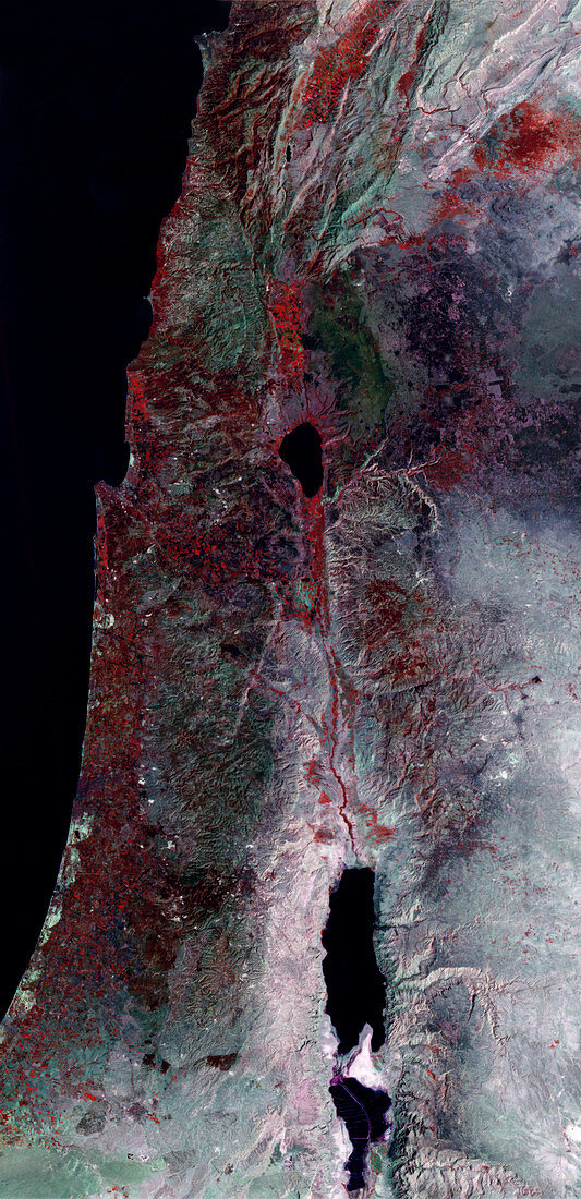
| Israel-Jordan border,satellite image. North is at top. Vegetation is red,barren land is white/green and urban areas are white. Water is black. Israel lies at left of the Dead Sea (black,lower centre) that lies on the Israel-Jordan border. The desert landscape of Jordan (right) contrasts with the cultivated fields (rectangles) in Israel. Israeli cities (white) are seen on the Mediterranean Sea coast. Mountains (top) make up Lebanon and part of Syria. This 180-kilometre-wide image was taken on 21 September 1995,in visible and infrared wavelengths,with the Thematic Mapper (TM) sensor on NASA's Landsat 5 satellite | |
| Lizenzart: | Lizenzpflichtig |
| Credit: | Science Photo Library / MDA Information Systems |
| Bildgröße: | 2910 px × 6007 px |
| Modell-Rechte: | nicht erforderlich |
| Eigentums-Rechte: | nicht erforderlich |
| Restrictions: | - |
Preise für dieses Bild ab 15 €
Universitäten & Organisationen
(Informationsmaterial Digital, Informationsmaterial Print, Lehrmaterial Digital etc.)
ab 15 €
Redaktionell
(Bücher, Bücher: Sach- und Fachliteratur, Digitale Medien (redaktionell) etc.)
ab 30 €
Werbung
(Anzeigen, Aussenwerbung, Digitale Medien, Fernsehwerbung, Karten, Werbemittel, Zeitschriften etc.)
ab 55 €
Handelsprodukte
(bedruckte Textilie, Kalender, Postkarte, Grußkarte, Verpackung etc.)
ab 75 €
Pauschalpreise
Rechtepakete für die unbeschränkte Bildnutzung in Print oder Online
ab 495 €
Keywords
- Anbau,
- Bauernhöfe,
- Berg,
- Berge,
- bewässert,
- Bewässerung,
- Bild,
- Bilder,
- Bodennutzung,
- Erdkunde,
- farbig,
- Foto,
- Fotos,
- Galiläa,
- geografisch,
- Geographie,
- infrarot,
- ir,
- Israel,
- Israelisch,
- Jordanien,
- Jüdisch,
- kultiviert,
- Küste,
- Küsten-,
- Küstenlinie,
- Land,
- Länder,
- Landwirtschaft,
- Libanesisch,
- Libanon,
- Meer,
- Mittlerer Osten,
- montan,
- Nation,
- Nationen,
- optisch,
- Pflanzen,
- Rand,
- Satellit,
- September,
- Sichtbar,
- Stadt,
- Städte,
- städtisch,
- Syrien,
- Syrisch,
- Tm,
- Tot,
- trocken,
- unfruchtbar,
- Vegetation,
- Wasser,
- Weltall,
- Wissenschaften,
- Wüste