Map of the Americas,1660
Bildnummer 11735557
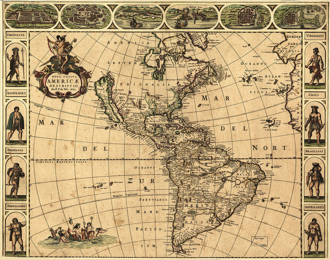
| 17th century map of the Americas. Published in Amsterdam in 1660,this map by the Dutch cartographer Frederick de Witt (1630-1706) shows the geography of the Americas,the New World being explored by Europeans. The exploration of South America was well advanced by this stage,but large swathes of North America had yet to be mapped. The artworks across top show various cities,from left to right: Cusco (Peru); Tenochtitlan (labelled Mexico,now Mexico City); Olinda (Brazil); Havana (Cuba); San Domingo (Hispaniola); and Cartagena (Colombia). The artworks at left and right show natives of Virginia (north-eastern North America),Chile and Brazil,and the 'Magellanic' people of Patagonia | |
| Lizenzart: | Lizenzpflichtig |
| Credit: | Science Photo Library / LIBRARY OF CONGRESS, GEOGRAPHY AND MAP DIVISION |
| Bildgröße: | 5304 px × 4190 px |
| Modell-Rechte: | nicht erforderlich |
| Eigentums-Rechte: | nicht erforderlich |
| Restrictions: | - |
Preise für dieses Bild ab 15 €
Universitäten & Organisationen
(Informationsmaterial Digital, Informationsmaterial Print, Lehrmaterial Digital etc.)
ab 15 €
Redaktionell
(Bücher, Bücher: Sach- und Fachliteratur, Digitale Medien (redaktionell) etc.)
ab 30 €
Werbung
(Anzeigen, Aussenwerbung, Digitale Medien, Fernsehwerbung, Karten, Werbemittel, Zeitschriften etc.)
ab 55 €
Handelsprodukte
(bedruckte Textilie, Kalender, Postkarte, Grußkarte, Verpackung etc.)
ab 75 €
Pauschalpreise
Rechtepakete für die unbeschränkte Bildnutzung in Print oder Online
ab 495 €
Keywords
- 1600er Jahre,
- 17. Jahrhundert,
- Alt,
- Brasilien,
- cartagena,
- Chile,
- Cusco,
- einheimisch,
- Erkundung,
- Französisch,
- geografisch,
- Geographie,
- Geschichte,
- Havanna,
- historisch,
- Karibik,
- Karte,
- Kartographie,
- Kolonie,
- Kolonien,
- Kontinent,
- Kontinente,
- Mittelalterlich,
- mittleren Alters,
- Neue Welt,
- Niederländisch,
- Nordamerika,
- nordamerikanisch,
- spanisch,
- Stadt,
- Städte,
- Südamerika,
- Südamerikanisch,
- Tenochtitlan,
- Virginia