Map of the world,1660
Bildnummer 11735553
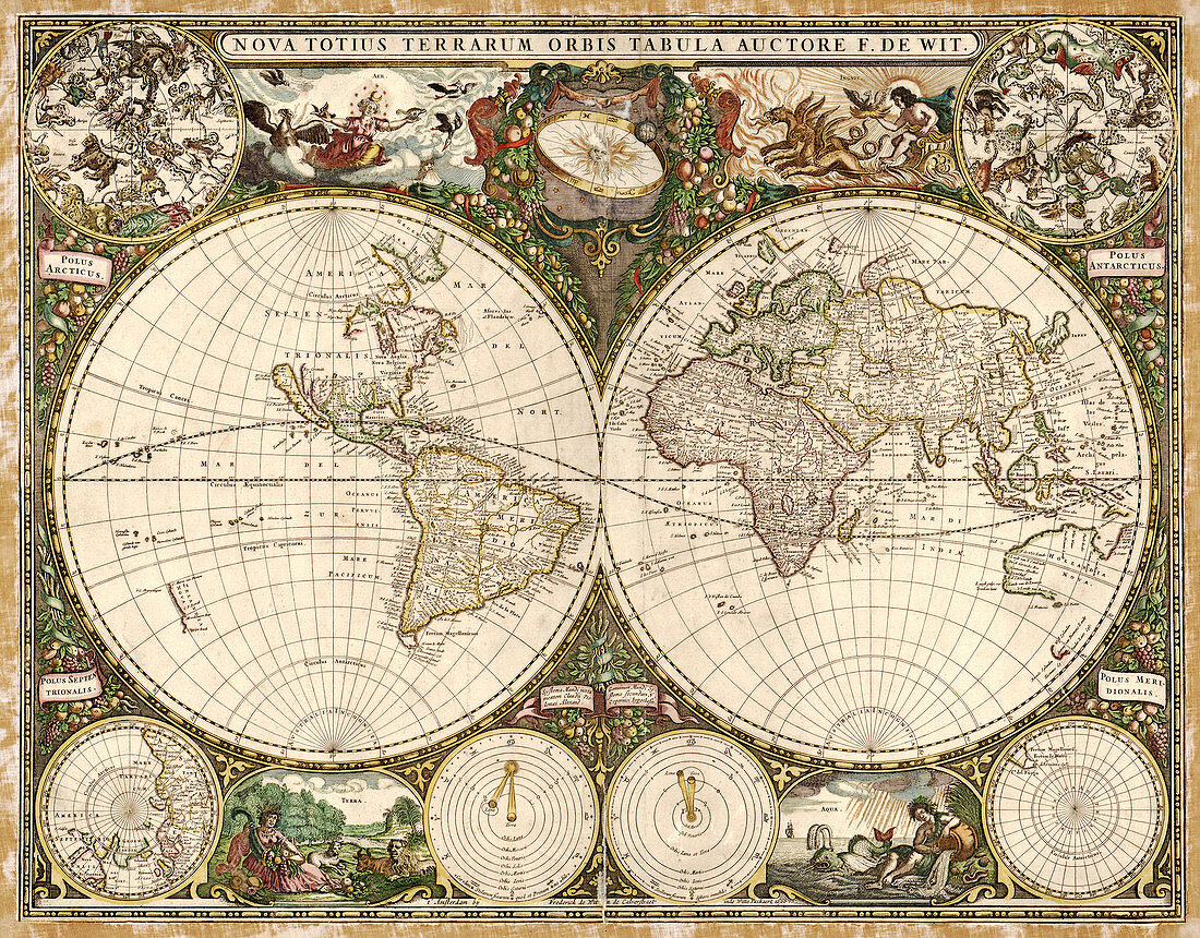
| 17th century map of the world. Published in Amsterdam in 1660,this map by the Dutch cartographer Frederick de Witt (1630-1706) shows the expanding exploration of the known world. The map divides the Earth into a western and eastern hemisphere. In the upper corners are the constellations of the northern and southern celestial poles,with the geographical poles in the lower corners. Above and below the hemispheres are the Aristotlean elements of Air,Fire,Earth and Water. At upper centre is the Sun,with the Earth orbiting on an ecliptic ring of zodaical symbols. At lower centre,Ptolemy's geocentric cosmology (left) is contrasted with the heliocentric Copernican cosmology (right) | |
| Lizenzart: | Lizenzpflichtig |
| Credit: | Science Photo Library / LIBRARY OF CONGRESS, GEOGRAPHY AND MAP DIVISION |
| Bildgröße: | 5136 px × 4017 px |
| Modell-Rechte: | nicht erforderlich |
| Eigentums-Rechte: | nicht erforderlich |
| Restrictions: | - |
Preise für dieses Bild ab 15 €
Universitäten & Organisationen
(Informationsmaterial Digital, Informationsmaterial Print, Lehrmaterial Digital etc.)
ab 15 €
Redaktionell
(Bücher, Bücher: Sach- und Fachliteratur, Digitale Medien (redaktionell) etc.)
ab 30 €
Werbung
(Anzeigen, Aussenwerbung, Digitale Medien, Fernsehwerbung, Karten, Werbemittel, Zeitschriften etc.)
ab 55 €
Handelsprodukte
(bedruckte Textilie, Kalender, Postkarte, Grußkarte, Verpackung etc.)
ab 75 €
Pauschalpreise
Rechtepakete für die unbeschränkte Bildnutzung in Print oder Online
ab 495 €
Keywords
- 1600er Jahre,
- 17. Jahrhundert,
- Alt,
- Alte Welt,
- Antarktis,
- Arktis,
- Asiatisch,
- Asien,
- copernicus,
- Erde,
- Erkundung,
- Eurasisch,
- Feuer,
- Französisch,
- geografisch,
- Geographie,
- Geschichte,
- Hemisphären,
- historisch,
- Karte,
- Kartographie,
- Kolonie,
- Kolonien,
- Kontinent,
- Kontinente,
- Kopernikanische Kosmologie,
- Luft,
- Mittelalterlich,
- mittleren Alters,
- Neue Welt,
- Niederländisch,
- Nordamerika,
- nordamerikanisch,
- spanisch,
- Sternbilder,
- Süd-,
- Südamerika,
- Südamerikanisch,
- Symbol,
- Symbole,
- Wasser,
- Welt,
- Western