Macrobian world map
Bildnummer 11735526
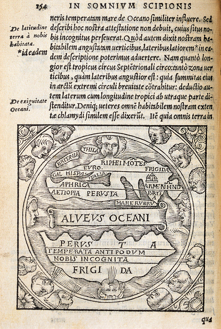
| Macrobian world map,1550 reprint of a world map published in 420 AD by the Roman philosopher Macrobius (395-423 AD). Macrobius depicted the world divided into five distinct climate zones; northern frigid zone,northern temperate zone (most of Europe and Asia),an uninhabited equatorial zone which includes a 'boiling sea' (Alveus Oceani),a temperate southern zone and finally a frigid southern zone. Microbian maps followed the theory that northern and southern hemisphere landmasses should exist to balance the world | |
| Lizenzart: | Lizenzpflichtig |
| Credit: | Science Photo Library / Bernard, George |
| Bildgröße: | 3474 px × 5185 px |
| Modell-Rechte: | nicht erforderlich |
| Eigentums-Rechte: | nicht erforderlich |
| Restrictions: | - |
Preise für dieses Bild ab 15 €
Universitäten & Organisationen
(Informationsmaterial Digital, Informationsmaterial Print, Lehrmaterial Digital etc.)
ab 15 €
Redaktionell
(Bücher, Bücher: Sach- und Fachliteratur, Digitale Medien (redaktionell) etc.)
ab 30 €
Werbung
(Anzeigen, Aussenwerbung, Digitale Medien, Fernsehwerbung, Karten, Werbemittel, Zeitschriften etc.)
ab 55 €
Handelsprodukte
(bedruckte Textilie, Kalender, Postkarte, Grußkarte, Verpackung etc.)
ab 75 €
Pauschalpreise
Rechtepakete für die unbeschränkte Bildnutzung in Print oder Online
ab 495 €