Asia,1630 Portuguese atlas
Bildnummer 11730633
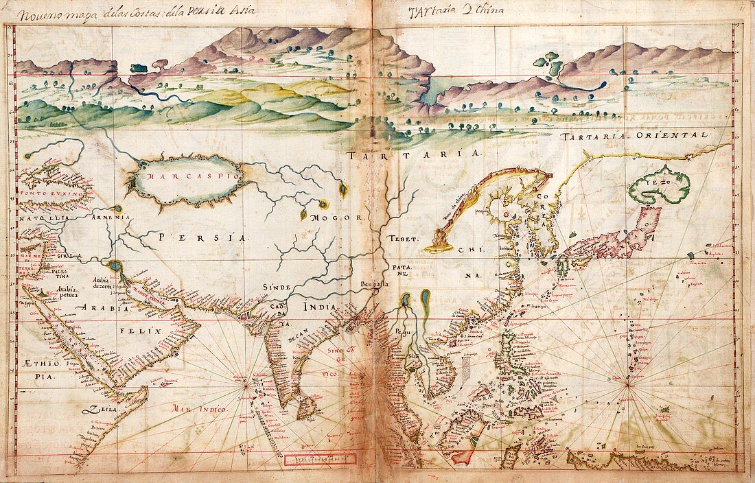
| Asia. 17th-century map of Asia and the new lands being discovered by European explorers in the Far East. The title (top) names Persia,Asia,Tartaria (Tartary) and China. Places shown include Ethiopia,Saudi Arabia,Anatolia (Turkey),Armenia,the Black Sea,the Caspian Sea,Persia,India,regions of Central Asia,Tibet,China,Korea,Japan,Borneo,the Philippines,and some of the islands of the Western Pacific. This map is from 'Taboas geraes de toda a navegacao' (1630),an atlas produced by Portuguese cartographer Joao Teixeira Albernaz I (active 1602-1648). Albernaz was the most prolific Portuguese cartographer of the seventeenth century | |
| Lizenzart: | Lizenzpflichtig |
| Credit: | Science Photo Library / LIBRARY OF CONGRESS, Geography and Map Division |
| Bildgröße: | 5740 px × 3673 px |
| Modell-Rechte: | nicht erforderlich |
| Eigentums-Rechte: | nicht erforderlich |
| Restrictions: | - |
Preise für dieses Bild ab 15 €
Universitäten & Organisationen
(Informationsmaterial Digital, Informationsmaterial Print, Lehrmaterial Digital etc.)
ab 15 €
Redaktionell
(Bücher, Bücher: Sach- und Fachliteratur, Digitale Medien (redaktionell) etc.)
ab 30 €
Werbung
(Anzeigen, Aussenwerbung, Digitale Medien, Fernsehwerbung, Karten, Werbemittel, Zeitschriften etc.)
ab 55 €
Handelsprodukte
(bedruckte Textilie, Kalender, Postkarte, Grußkarte, Verpackung etc.)
ab 75 €
Pauschalpreise
Rechtepakete für die unbeschränkte Bildnutzung in Print oder Online
ab 495 €
Keywords
- 1600er Jahre,
- 17. Jahrhundert,
- Afrikanisch,
- Anatolien,
- Armenien,
- Asiatisch,
- Asien,
- Äthiopien,
- Atlas,
- China,
- Chinesische Mauer,
- Diagramm,
- Erkundung,
- Fernost,
- geografisch,
- Geographie,
- Geschichte,
- historisch,
- Illustration,
- Indien,
- Japan,
- Karte,
- Kartographie,
- Kaspisches Meer,
- Korea,
- Kunstwerk,
- Niemand,
- Persien,
- Philippinen,
- Portugiesisch,
- Russland,
- Saudi Arabien,
- schwarzes Meer,
- Sibirien,
- Tatarstan,
- Tibet,
- Truthahn,
- Veröffentlichung,
- Zentralasien