Chart of the Mediterranean,17th century
Bildnummer 11727761
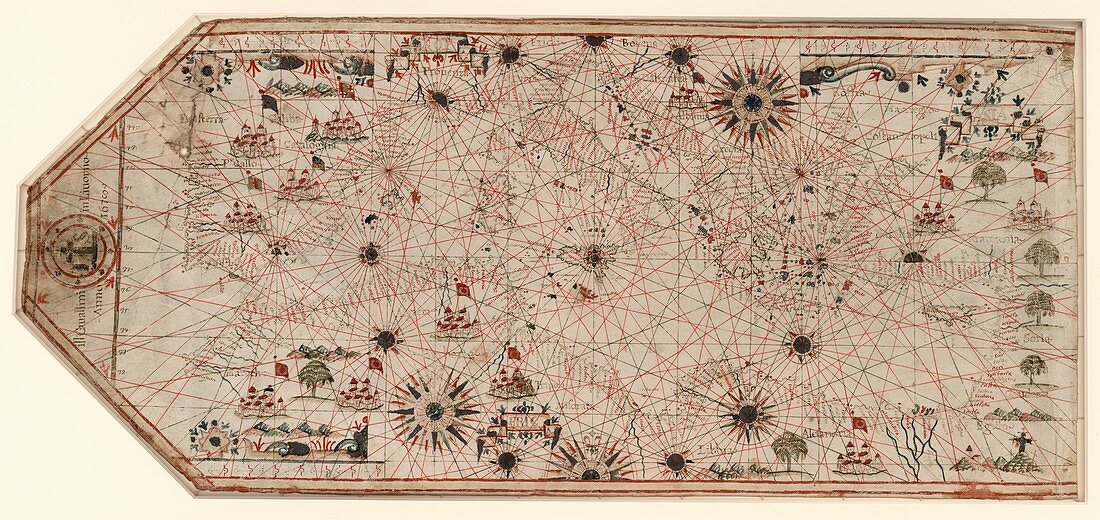
| Chart of the Mediterranean. 17th-century chart of the Mediterranean coast and the coast of Portugal and north-west Africa. This is from a portolan atlas (a collection of navigational charts). It was produced either by Italian cartographer Giovanni Battista Cavallini (active 1630-1669),or his son Pietro,or by his workshop. This chart includes 16 wind roses and numerous illustrations including Islamic flags over cities in North Africa and the Middle East,and a depiction of the crucifixion to represent the Holy Land. The lines on the map are rhumb lines,designed to make it easier to steer a straight course. The map dates from 1678 (publication details at left) | |
| Lizenzart: | Lizenzpflichtig |
| Credit: | Science Photo Library / LIBRARY OF CONGRESS, Geography and Map Division |
| Bildgröße: | 6425 px × 3035 px |
| Modell-Rechte: | nicht erforderlich |
| Eigentums-Rechte: | nicht erforderlich |
| Restrictions: | - |
Preise für dieses Bild ab 15 €
Universitäten & Organisationen
(Informationsmaterial Digital, Informationsmaterial Print, Lehrmaterial Digital etc.)
ab 15 €
Redaktionell
(Bücher, Bücher: Sach- und Fachliteratur, Digitale Medien (redaktionell) etc.)
ab 30 €
Werbung
(Anzeigen, Aussenwerbung, Digitale Medien, Fernsehwerbung, Karten, Werbemittel, Zeitschriften etc.)
ab 55 €
Handelsprodukte
(bedruckte Textilie, Kalender, Postkarte, Grußkarte, Verpackung etc.)
ab 75 €
Pauschalpreise
Rechtepakete für die unbeschränkte Bildnutzung in Print oder Online
ab 495 €
Keywords
- 1600er Jahre,
- 17. Jahrhundert,
- Afrika,
- Afrikanisch,
- Ägypten,
- Algerien,
- Diagramm,
- Europa,
- europäisch,
- Frankreich,
- geografisch,
- Geographie,
- Geschichte,
- Griechenland,
- heiliges Land,
- historisch,
- Illustration,
- Israel,
- Italien,
- Karte,
- Kartographie,
- Kreuzigung,
- Kunstwerk,
- Küste,
- Küsten-,
- Linien,
- Marokko,
- Meer,
- Meereskunde,
- Mittelmeer,
- Mittlerer Osten,
- Muslim,
- Nahost,
- Navigation,
- Niemand,
- Palästina,
- Portugal,
- Religion,
- religiös,
- Spanien,
- Truthahn,
- Tunesien